|
|
|
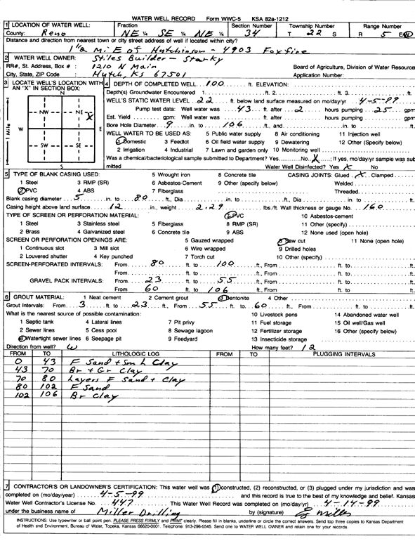
Specific Water Well Detail |
|
|
| Location Info | |||
| Owner: Stiles Builders/Starky | Status: Constructed | ||
| Location: T22S, R5W, Sec. 34, NE SE NE | County: Reno | ||
| Directions: 4903 Foxfire - from Hutchinson: 1.5 mi E | |||
| Latitude: 38.0964767 | Longitude: -97.8494727 | Datum NAD 27 | |
| Latitude: 38.0964875 | Longitude: -97.8498005 | Datum NAD 83 | |
| Longitude and latitude calculated by Survey from township-range-section-quarter calls. Only good to within the quarter call accuracy. | |||
| View well on interactive map | |||
| General Info | ||
| Well Depth: 100 ft. | Elevation: ft. | |
| Static Water Level: 22 ft. | Est. Yield: gpm. | |
| Comp. Date: 05-Apr-1999 | Well Use: Domestic | |
| DWR Applic. #: | Other ID: | |
| Driller Info | ||
| Driller: Miller Drilling | License #: 447 | |
| Scanned Form | View scan |
|
Chemical Sample Submitted?:
Water Well disinfected?: | ||
| Casing Info | ||
| Casing Type:
Casing Joints: |
Diam: in. to ft | |
| Casing height above land surface: in
Casing Weight: lbs/ft Wall thickness or gauge no.: | ||
| Screen and Perforation Info | ||
| Screen Type: | Screen Openings: | |
| Screen-perforated intervals | From: ft to ft | |
| Gravel pack intervals | From: ft to ft | |
| Grout Info | ||
| Grout used: | From: to ft | |
| Source of Possible Contamination | ||
| Source: | ||
| Direction from well: | Distance: ft | |
| Lithologic Log
(Log data entered by KGS.) | ||
| From: 0 ft. to 43 ft. | fine sand and small layers of clay | |
| From: 43 ft. to 70 ft. | brown and gray clay | |
| From: 70 ft. to 80 ft. | layers of fine sand and clay | |
| From: 80 ft. to 102 ft. | fine sand | |
| From: 102 ft. to 106 ft. | brown clay | |