|
|
|
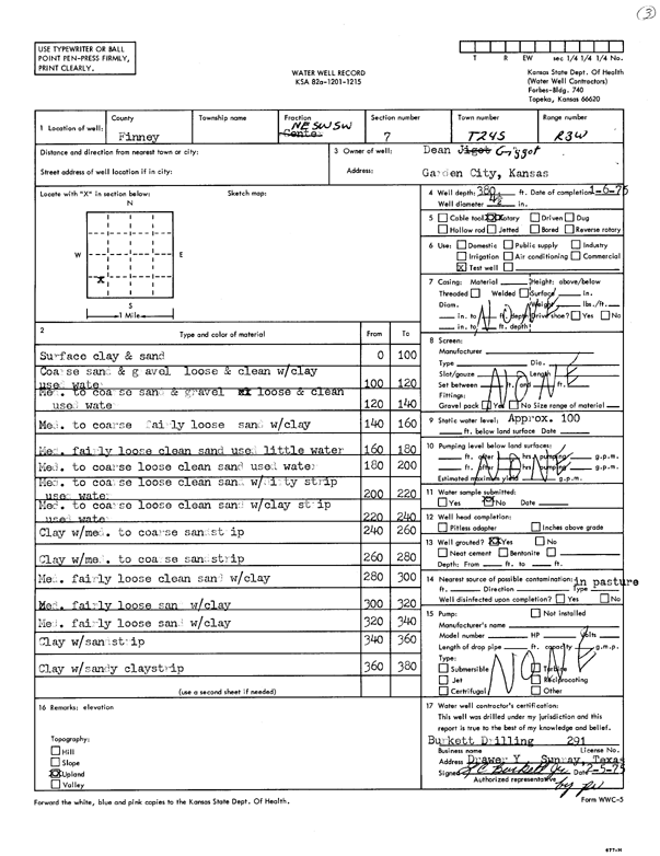
Specific Water Well Detail |
|
|
| Location Info | |||
| Owner: Gigot, Dean | Status: Constructed | ||
| Location: T24S, R33W, Sec. 7, NE SW SW | County: Finney | ||
| Directions: | |||
| Latitude: 37.9773736 | Longitude: -100.9891543 | Datum NAD 27 | |
| Latitude: 37.9773979 | Longitude: -100.9895986 | Datum NAD 83 | |
| Longitude and latitude calculated by Survey from township-range-section-quarter calls. Only good to within the quarter call accuracy. | |||
| View well on interactive map | |||
| General Info | ||
| Well Depth: 380 ft. | Elevation: ft. | |
| Static Water Level: ft. | Est. Yield: gpm. | |
| Comp. Date: 06-Jan-1975 | Well Use: Test hole/well | |
| DWR Applic. #: | Other ID: | |
| Driller Info | ||
| Driller: L.C. Burkett Drilling | License #: 291 | |
| Scanned Form | View scan |
|
Chemical Sample Submitted?:
Water Well disinfected?: | ||
| Casing Info | ||
| Casing Type:
Casing Joints: |
Diam: in. to ft | |
| Casing height above land surface: in
Casing Weight: lbs/ft Wall thickness or gauge no.: | ||
| Screen and Perforation Info | ||
| Screen Type: | Screen Openings: | |
| Screen-perforated intervals | From: ft to ft | |
| Gravel pack intervals | From: ft to ft | |
| Grout Info | ||
| Grout used: | From: to ft | |
| Source of Possible Contamination | ||
| Source: | ||
| Direction from well: | Distance: ft | |
| Lithologic Log
(Log data entered by KGS.) | ||
| From: 0 ft. to 100 ft. | surface clay and sand | |
| From: 100 ft. to 120 ft. | coarse sand and gravel loose and clean with clay used water | |
| From: 120 ft. to 140 ft. | med. to coarse sand and gravel loose and clean used water | |
| From: 140 ft. to 160 ft. | med. to coarse fairly loose sand with clay | |
| From: 160 ft. to 180 ft. | med. fairly loose clean sand used little water | |
| From: 180 ft. to 200 ft. | med. to coarse loose clean sand used water | |
| From: 200 ft. to 220 ft. | med. to coarse loose clean sand with dirty strip used water | |
| From: 220 ft. to 240 ft. | med. to coarse loose clean sand with clay strip used water | |
| From: 240 ft. to 260 ft. | clay with med. to coarse sand strip | |
| From: 260 ft. to 280 ft. | clay with med. to coarse sand strip | |
| From: 280 ft. to 300 ft. | med. fairly loose clean sand with clay | |
| From: 300 ft. to 320 ft. | med. fairly loose sand with clay | |
| From: 320 ft. to 340 ft. | med. fairly loose sand /clay | |
| From: 340 ft. to 360 ft. | clay with sand strip | |
| From: 360 ft. to 380 ft. | clay with sandy clay strip | |