|
|
|
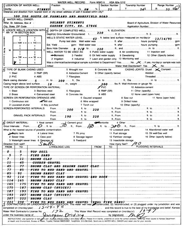
Specific Water Well Detail |
|
|
| Location Info | |||
| Owner: Stimentz, Delbert | Status: Constructed | ||
| Location: T24S, R32W, Sec. 22, SW | County: Finney | ||
| Directions: 900 feet S of Farmland and Mansfield Rd | |||
| Latitude: 37.9494828 | Longitude: -100.8239418 | Datum NAD 27 | |
| Latitude: 37.9495056 | Longitude: -100.8243798 | Datum NAD 83 | |
| Longitude and latitude calculated by Survey from township-range-section-quarter calls. Only good to within the quarter call accuracy. | |||
| View well on interactive map | |||
| General Info | ||
| Well Depth: 220 ft. | Elevation: ft. | |
| Static Water Level: 42 ft. | Est. Yield: gpm. | |
| Comp. Date: 14-Dec-1995 | Well Use: Domestic | |
| DWR Applic. #: | Other ID: | |
| Driller Info | ||
| Driller: Jonagan Water Well Service LLC | License #: 172 | |
| Scanned Form | View scan |
|
Chemical Sample Submitted?:
Water Well disinfected?: | ||
| Casing Info | ||
| Casing Type:
Casing Joints: |
Diam: in. to ft | |
| Casing height above land surface: in
Casing Weight: lbs/ft Wall thickness or gauge no.: | ||
| Screen and Perforation Info | ||
| Screen Type: | Screen Openings: | |
| Screen-perforated intervals | From: ft to ft | |
| Gravel pack intervals | From: ft to ft | |
| Grout Info | ||
| Grout used: | From: to ft | |
| Source of Possible Contamination | ||
| Source: | ||
| Direction from well: | Distance: ft | |
| Lithologic Log
(Log data entered by KGS.) | ||
| From: 0 ft. to 5 ft. | top soil | |
| From: 5 ft. to 7 ft. | fine sand | |
| From: 7 ft. to 11 ft. | brown clay | |
| From: 11 ft. to 45 ft. | coarse gravel | |
| From: 45 ft. to 77 ft. | brown clay and brown sandy clay | |
| From: 77 ft. to 85 ft. | fine to medium sand and gravel | |
| From: 85 ft. to 92 ft. | brown sandy clay | |
| From: 92 ft. to 114 ft. | fine to medium sand and gravel and rock | |
| From: 114 ft. to 165 ft. | brown sandy clay | |
| From: 165 ft. to 175 ft. | fine to medium sand and gravel | |
| From: 175 ft. to 187 ft. | brown clay (sticky) | |
| From: 187 ft. to 193 ft. | fine to medium sand and gravel | |
| From: 193 ft. to 207 ft. | brown clay (sticky) | |
| From: 207 ft. to 222 ft. | brown clay | |
| From: 222 ft. to 230 ft. | fine to medium sand and gravel (real fine sand) | |