|
|
|
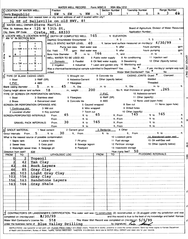
Specific Water Well Detail |
|
|
| Location Info | |||
| Owner: Martin, Steve | Status: Constructed | ||
| Location: T3S, R3W, Sec. 25, SW SW NW | County: Republic | ||
| Directions: From Belleville, 3.5 miles Southeast on old Hwy 81 | |||
| Latitude: 39.7626942 | Longitude: -97.612967 | Datum NAD 27 | |
| Latitude: 39.7626988 | Longitude: -97.613286 | Datum NAD 83 | |
| Longitude and latitude calculated by Survey from township-range-section-quarter calls. Only good to within the quarter call accuracy. | |||
| View well on interactive map | |||
| General Info | ||
| Well Depth: 165 ft. | Elevation: ft. | |
| Static Water Level: 40 ft. | Est. Yield: 10 gpm. | |
| Comp. Date: 30-May-1999 | Well Use: Domestic | |
| DWR Applic. #: | Other ID: | |
| Driller Info | ||
| Driller: Blue Valley Drilling | License #: 518 | |
| Scanned Form | View scan |
|
Chemical Sample Submitted?:
Water Well disinfected?: | ||
| Casing Info | ||
| Casing Type:
Casing Joints: |
Diam: in. to ft | |
| Casing height above land surface: in
Casing Weight: lbs/ft Wall thickness or gauge no.: | ||
| Screen and Perforation Info | ||
| Screen Type: | Screen Openings: | |
| Screen-perforated intervals | From: ft to ft | |
| Gravel pack intervals | From: ft to ft | |
| Grout Info | ||
| Grout used: | From: to ft | |
| Source of Possible Contamination | ||
| Source: | ||
| Direction from well: | Distance: ft | |
| Lithologic Log
(Log data entered by KGS.) | ||
| From: 0 ft. to 2 ft. | top soil | |
| From: 2 ft. to 42 ft. | tan clay | |
| From: 42 ft. to 46 ft. | rock layers | |
| From: 46 ft. to 85 ft. | gray clay | |
| From: 85 ft. to 103 ft. | light gray clay | |
| From: 103 ft. to 156 ft. | gray clay | |
| From: 156 ft. to 163 ft. | sandstone layers | |
| From: 163 ft. to 166 ft. | gray clay | |