|
|
|
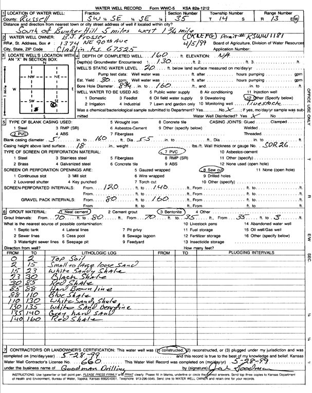
Specific Water Well Detail |
|
|
| Location Info | |||
| Owner: Prosser, B.J. | Status: Constructed | ||
| Location: T14S, R13W, Sec. 35, SW SE SE | County: Russell | ||
| Directions: S of Bunker Hill, 5 mi W, 1.75 mi | |||
| Latitude: 38.7848483 | Longitude: -98.7282431 | Datum NAD 27 | |
| Latitude: 38.7848594 | Longitude: -98.7285994 | Datum NAD 83 | |
| Longitude and latitude calculated by Survey from township-range-section-quarter calls. Only good to within the quarter call accuracy. | |||
| View well on interactive map | |||
| General Info | ||
| Well Depth: 160 ft. | Elevation: ft. | |
| Static Water Level: 20 ft. | Est. Yield: gpm. | |
| Comp. Date: 28-May-1999 | Well Use: Domestic, Livestock | |
| DWR Applic. #: RSWW 1181 | Other ID: | |
| Driller Info | ||
| Driller: Jack Goodman Water Well Drilling | License #: 660 | |
| Scanned Form | View scan |
|
Chemical Sample Submitted?:
Water Well disinfected?: | ||
| Casing Info | ||
| Casing Type:
Casing Joints: |
Diam: in. to ft | |
| Casing height above land surface: in
Casing Weight: lbs/ft Wall thickness or gauge no.: | ||
| Screen and Perforation Info | ||
| Screen Type: | Screen Openings: | |
| Screen-perforated intervals | From: ft to ft | |
| Gravel pack intervals | From: ft to ft | |
| Grout Info | ||
| Grout used: | From: to ft | |
| Source of Possible Contamination | ||
| Source: | ||
| Direction from well: | Distance: ft | |
| Lithologic Log
(Log data entered by KGS.) | ||
| From: 0 ft. to 2 ft. | top soil | |
| From: 2 ft. to 15 ft. | small to large loose sand | |
| From: 15 ft. to 23 ft. | white sandy shale | |
| From: 23 ft. to 30 ft. | black shale | |
| From: 30 ft. to 85 ft. | red shale | |
| From: 85 ft. to 88 ft. | hard brown limestone | |
| From: 88 ft. to 110 ft. | blue shale | |
| From: 110 ft. to 130 ft. | white sandy shale | |
| From: 130 ft. to 135 ft. | white sand, very fine | |
| From: 135 ft. to 140 ft. | gray hard sand | |
| From: 140 ft. to 160 ft. | red shale | |