|
|
|
Specific Water Well Detail |
|
|
| Location Info | |||
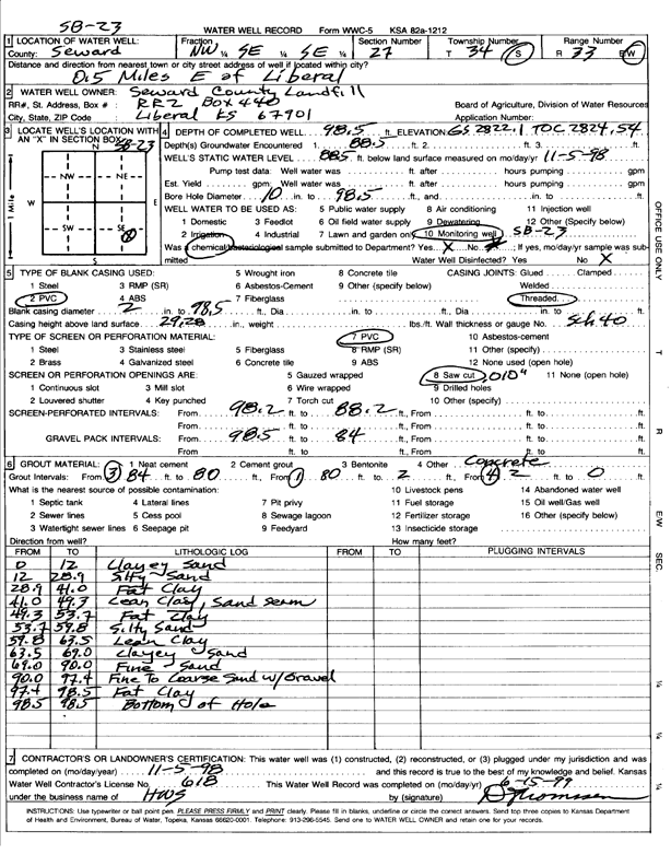
| Owner: Seward County Landfill | Status: Constructed | ||
| Location: T34S, R33W, Sec. 27, NW SE SE | County: Seward | ||
| Directions: from Liberal: .5 mi E | |||
| Latitude: 37.0571034 | Longitude: -100.8892088 | Datum NAD 27 | |
| Latitude: 37.0571285 | Longitude: -100.8896509 | Datum NAD 83 | |
| Longitude and latitude calculated by Survey from township-range-section-quarter calls. Only good to within the quarter call accuracy. | |||
| View well on interactive map | |||
| General Info | ||
| Well Depth: 98.5 ft. | Elevation: 2822 ft. | |
| Static Water Level: 88.5 ft. | Est. Yield: gpm. | |
| Comp. Date: 05-Nov-1998 | Well Use: Monitoring well/observation/piezometer | |
| DWR Applic. #: | Other ID: | |
| Driller Info | ||
| Driller: HWS | License #: 618 | |
| Scanned Form | View scan |
|
Chemical Sample Submitted?:
Water Well disinfected?: | ||
| Casing Info | ||
| Casing Type:
Casing Joints: |
Diam: in. to ft | |
| Casing height above land surface: in
Casing Weight: lbs/ft Wall thickness or gauge no.: | ||
| Screen and Perforation Info | ||
| Screen Type: | Screen Openings: | |
| Screen-perforated intervals | From: ft to ft | |
| Gravel pack intervals | From: ft to ft | |
| Grout Info | ||
| Grout used: | From: to ft | |
| Source of Possible Contamination | ||
| Source: | ||
| Direction from well: | Distance: ft | |
| Lithologic Log
(Log data entered by KGS.) | ||
| From: 0 ft. to 12 ft. | clayey sand | |
| From: 12 ft. to 28.9 ft. | silty sand | |
| From: 28.9 ft. to 41 ft. | fat clay | |
| From: 41 ft. to 49.3 ft. | lean clay, sand seam | |
| From: 49.3 ft. to 53.7 ft. | fat clay | |
| From: 53.7 ft. to 59.8 ft. | silty sand | |
| From: 59.8 ft. to 63.5 ft. | lean clay | |
| From: 63.5 ft. to 69 ft. | clayey sand | |
| From: 69 ft. to 90 ft. | fine sand | |
| From: 90 ft. to 97.4 ft. | fine to coarse sand with gravel | |
| From: 97.4 ft. to 98.5 ft. | fat clay | |