|
|
|
Specific Water Well Detail |
|
|
| Location Info | |||
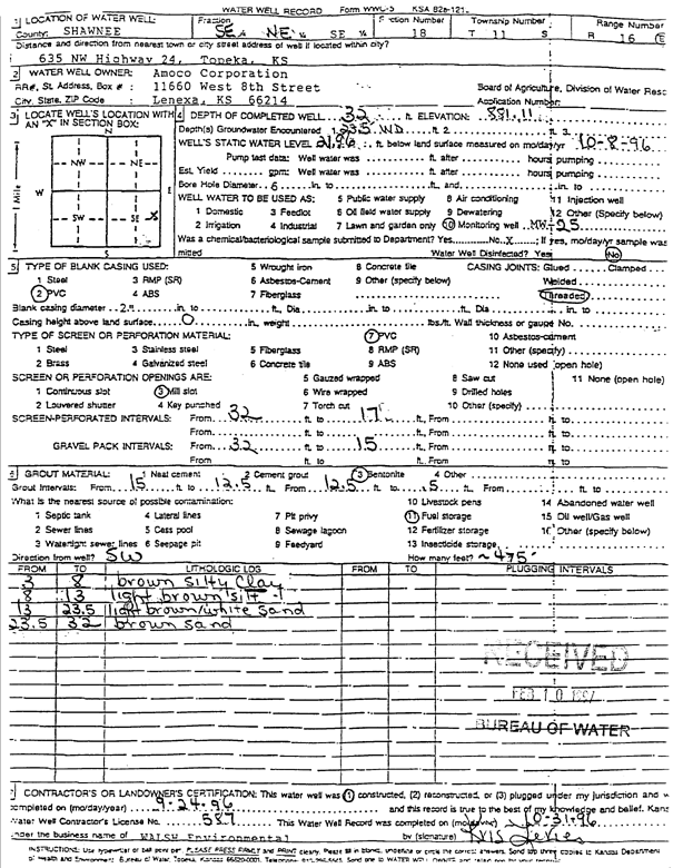
| Owner: Amoco Oil Co. | Status: Constructed | ||
| Location: T11S, R16E, Sec. 18, SE NE SE | County: Shawnee | ||
| Directions: 635 NW Hwy 24, Topeka | |||
| Latitude: 39.0922135 | Longitude: -95.6703517 | Datum NAD 27 | |
| Latitude: 39.092213 | Longitude: -95.6706107 | Datum NAD 83 | |
| Longitude and latitude calculated by Survey from township-range-section-quarter calls. Only good to within the quarter call accuracy. | |||
| View well on interactive map | |||
| General Info | ||
| Well Depth: 32 ft. | Elevation: 881.11 ft. | |
| Static Water Level: 21.96 ft. | Est. Yield: gpm. | |
| Comp. Date: 24-Sep-1996 | Well Use: Monitoring well/observation/piezometer | |
| DWR Applic. #: | Other ID: MW 25 | |
| Driller Info | ||
| Driller: Walsh Environmental | License #: 587 | |
| Scanned Form | View scan |
|
Chemical Sample Submitted?:
Water Well disinfected?: | ||
| Casing Info | ||
| Casing Type:
Casing Joints: |
Diam: in. to ft | |
| Casing height above land surface: in
Casing Weight: lbs/ft Wall thickness or gauge no.: | ||
| Screen and Perforation Info | ||
| Screen Type: | Screen Openings: | |
| Screen-perforated intervals | From: ft to ft | |
| Gravel pack intervals | From: ft to ft | |
| Grout Info | ||
| Grout used: | From: to ft | |
| Source of Possible Contamination | ||
| Source: | ||
| Direction from well: | Distance: ft | |
| Lithologic Log
(Log data entered by KGS.) | ||
| From: 3 ft. to 8 ft. | brown silty clay | |
| From: 8 ft. to 13 ft. | light brown silt | |
| From: 13 ft. to 23.5 ft. | light brown-white sand | |
| From: 23.5 ft. to 32 ft. | brown sand | |