|
|
|
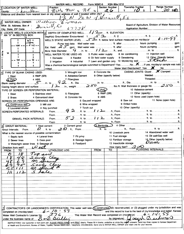
Specific Water Well Detail |
|
|
| Location Info | |||
| Owner: Bixenman, William | Status: Constructed | ||
| Location: T10S, R30W, Sec. 26, NW NW NE | County: Sheridan | ||
| Directions: from Grinnell: 1.5 mi N, .5 mi W | |||
| Latitude: 39.161272 | Longitude: -100.6360642 | Datum NAD 27 | |
| Latitude: 39.1612794 | Longitude: -100.6364851 | Datum NAD 83 | |
| Longitude and latitude calculated by Survey from township-range-section-quarter calls. Only good to within the quarter call accuracy. | |||
| View well on interactive map | |||
| General Info | ||
| Well Depth: 112 ft. | Elevation: ft. | |
| Static Water Level: 52 ft. | Est. Yield: 25 gpm. | |
| Comp. Date: 10-Jun-1999 | Well Use: Domestic, Livestock | |
| DWR Applic. #: | Other ID: | |
| Driller Info | ||
| Driller: B & B Drilling | License #: 376 | |
| Scanned Form | View scan |
|
Chemical Sample Submitted?:
Water Well disinfected?: | ||
| Casing Info | ||
| Casing Type:
Casing Joints: |
Diam: in. to ft | |
| Casing height above land surface: in
Casing Weight: lbs/ft Wall thickness or gauge no.: | ||
| Screen and Perforation Info | ||
| Screen Type: | Screen Openings: | |
| Screen-perforated intervals | From: ft to ft | |
| Gravel pack intervals | From: ft to ft | |
| Grout Info | ||
| Grout used: | From: to ft | |
| Source of Possible Contamination | ||
| Source: | ||
| Direction from well: | Distance: ft | |
| Lithologic Log
(Log data entered by KGS.) | ||
| From: 0 ft. to 18 ft. | Top soil | |
| From: 18 ft. to 48 ft. | Sandy clay | |
| From: 48 ft. to 69 ft. | Medium gravel | |
| From: 69 ft. to 95 ft. | Sandy clay | |
| From: 95 ft. to 111 ft. | Medium gravel | |
| From: 111 ft. to 112 ft. | Shale | |