|
|
|
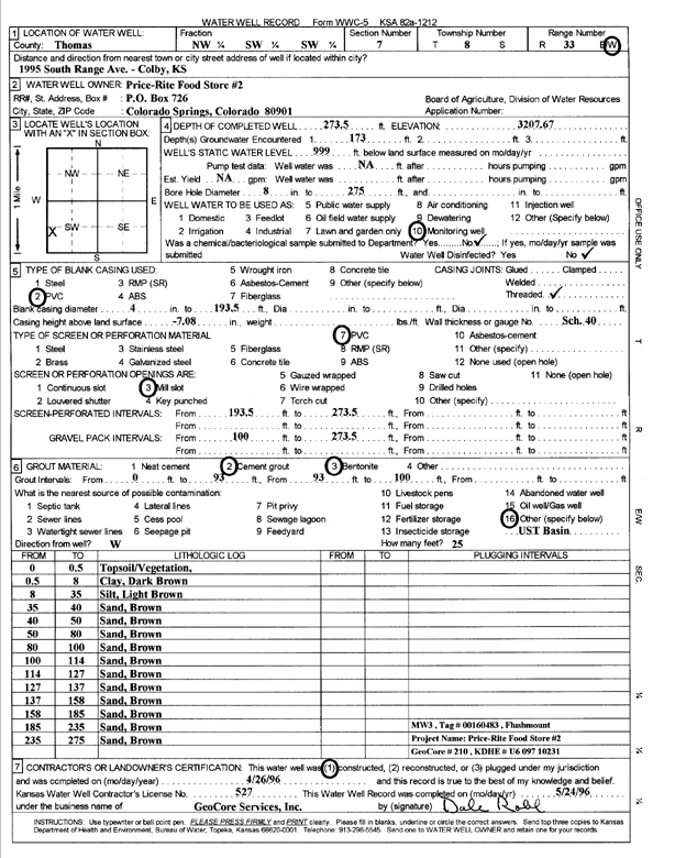
Specific Water Well Detail |
|
|
| Location Info | |||
| Owner: Price-Rite Food Store 2 | Status: Constructed | ||
| Location: T8S, R33W, Sec. 7, NW SW SW | County: Thomas | ||
| Directions: 1995 S Range Ave, Colby (tag 00160483) | |||
| Latitude: 39.3679388 | Longitude: -101.0533887 | Datum NAD 27 | |
| Latitude: 39.3679428 | Longitude: -101.0538216 | Datum NAD 83 | |
| Longitude and latitude calculated by Survey from township-range-section-quarter calls. Only good to within the quarter call accuracy. | |||
| View well on interactive map | |||
| General Info | ||
| Well Depth: 273.5 ft. | Elevation: 3207.67 ft. | |
| Static Water Level: ft. | Est. Yield: gpm. | |
| Comp. Date: 26-Apr-1996 | Well Use: Monitoring well/observation/piezometer | |
| DWR Applic. #: | Other ID: MW 3 | |
| Driller Info | ||
| Driller: GeoCore Services Inc. | License #: 527 | |
| Scanned Form | View scan |
|
Chemical Sample Submitted?:
Water Well disinfected?: | ||
| Casing Info | ||
| Casing Type:
Casing Joints: |
Diam: in. to ft | |
| Casing height above land surface: in
Casing Weight: lbs/ft Wall thickness or gauge no.: | ||
| Screen and Perforation Info | ||
| Screen Type: | Screen Openings: | |
| Screen-perforated intervals | From: ft to ft | |
| Gravel pack intervals | From: ft to ft | |
| Grout Info | ||
| Grout used: | From: to ft | |
| Source of Possible Contamination | ||
| Source: | ||
| Direction from well: | Distance: ft | |
| Lithologic Log
(Log data entered by KGS.) | ||
| From: 0 ft. to .5 ft. | top soil, vegetation | |
| From: .5 ft. to 8 ft. | clay, dark brown | |
| From: 8 ft. to 35 ft. | silt, light brown | |
| From: 35 ft. to 40 ft. | sand, brown | |
| From: 40 ft. to 50 ft. | sand, brown | |
| From: 50 ft. to 80 ft. | sand, brown | |
| From: 80 ft. to 100 ft. | sand, brown | |
| From: 100 ft. to 114 ft. | sand, brown | |
| From: 114 ft. to 127 ft. | sand, brown | |
| From: 127 ft. to 137 ft. | sand, brown | |
| From: 137 ft. to 158 ft. | sand, brown | |
| From: 158 ft. to 185 ft. | sand, brown | |
| From: 185 ft. to 235 ft. | sand, brown | |
| From: 235 ft. to 275 ft. | sand, brown | |