|
|
|
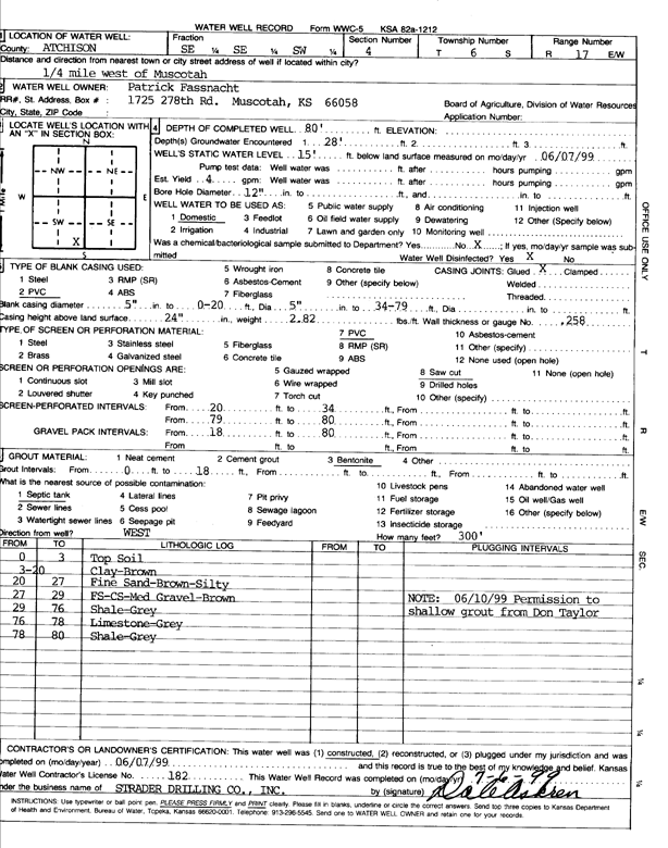
Specific Water Well Detail |
|
|
| Location Info | |||
| Owner: Fassnacht, Patrick | Status: Constructed | ||
| Location: T6S, R17E, Sec. 4, SE SE SW | County: Atchison | ||
| Directions: from Muscotah: .25 mi W | |||
| Latitude: 39.5514105 | Longitude: -95.5257293 | Datum NAD 27 | |
| Latitude: 39.5514098 | Longitude: -95.5259857 | Datum NAD 83 | |
| Longitude and latitude calculated by Survey from township-range-section-quarter calls. Only good to within the quarter call accuracy. | |||
| View well on interactive map | |||
| General Info | ||
| Well Depth: 80 ft. | Elevation: ft. | |
| Static Water Level: 15 ft. | Est. Yield: 4 gpm. | |
| Comp. Date: 07-Jun-1999 | Well Use: Domestic | |
| DWR Applic. #: | Other ID: | |
| Driller Info | ||
| Driller: Strader Drilling Co., Inc. | License #: 182 | |
| Scanned Form | View scan |
|
Chemical Sample Submitted?:
Water Well disinfected?: | ||
| Casing Info | ||
| Casing Type:
Casing Joints: |
Diam: in. to ft | |
| Casing height above land surface: in
Casing Weight: lbs/ft Wall thickness or gauge no.: | ||
| Screen and Perforation Info | ||
| Screen Type: | Screen Openings: | |
| Screen-perforated intervals | From: ft to ft | |
| Gravel pack intervals | From: ft to ft | |
| Grout Info | ||
| Grout used: | From: to ft | |
| Source of Possible Contamination | ||
| Source: | ||
| Direction from well: | Distance: ft | |
| Lithologic Log
(Log data entered by KGS.) | ||
| From: 0 ft. to 3 ft. | Topsoil | |
| From: 3 ft. to 20 ft. | Clay, brown | |
| From: 20 ft. to 27 ft. | Fine sand, brown, silty | |
| From: 27 ft. to 29 ft. | Fine sand, coarse sand, medium gravel, brown | |
| From: 29 ft. to 76 ft. | Shale, gray | |
| From: 76 ft. to 78 ft. | Limestone, gray | |
| From: 78 ft. to 80 ft. | Shale, gray | |