|
|
|
Specific Water Well Detail |
|
|
| Location Info | |||
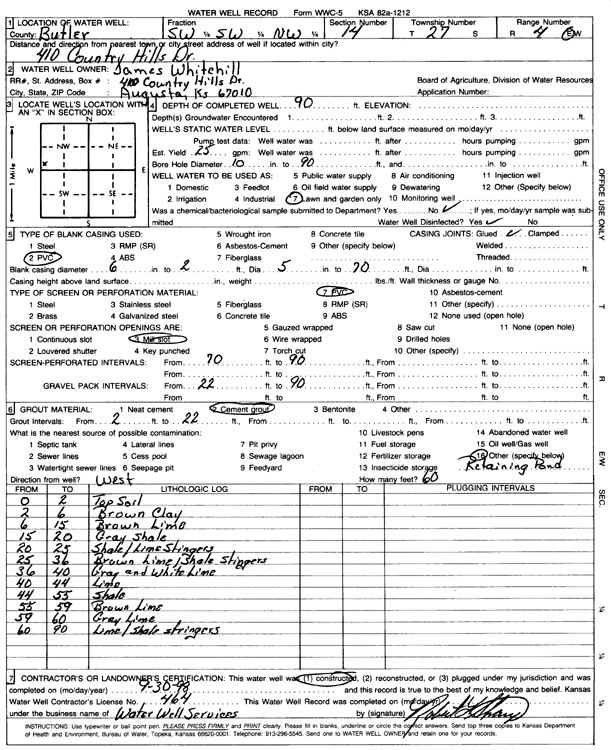
| Owner: Whitehill, James | Status: Constructed | ||
| Location: T27S, R4E, Sec. 14, SW SW NW | County: Butler | ||
| Directions: 410 Country Hills Dr, Augusta | |||
| Latitude: 37.7019344 | Longitude: -96.969956 | Datum NAD 27 | |
| Latitude: 37.701952 | Longitude: -96.9702694 | Datum NAD 83 | |
| Longitude and latitude calculated by Survey from township-range-section-quarter calls. Only good to within the quarter call accuracy. | |||
| View well on interactive map | |||
| General Info | ||
| Well Depth: 90 ft. | Elevation: ft. | |
| Static Water Level: ft. | Est. Yield: 25 gpm. | |
| Comp. Date: 30-Sep-1998 | Well Use: Domestic, Lawn and Garden | |
| DWR Applic. #: | Other ID: | |
| Driller Info | ||
| Driller: Robert L. Sharp Water Well Services | License #: 464 | |
| Scanned Form | View scan |
|
Chemical Sample Submitted?:
Water Well disinfected?: | ||
| Casing Info | ||
| Casing Type:
Casing Joints: |
Diam: in. to ft | |
| Casing height above land surface: in
Casing Weight: lbs/ft Wall thickness or gauge no.: | ||
| Screen and Perforation Info | ||
| Screen Type: | Screen Openings: | |
| Screen-perforated intervals | From: ft to ft | |
| Gravel pack intervals | From: ft to ft | |
| Grout Info | ||
| Grout used: | From: to ft | |
| Source of Possible Contamination | ||
| Source: | ||
| Direction from well: | Distance: ft | |
| Lithologic Log
(Log data entered by KGS.) | ||
| From: 0 ft. to 2 ft. | top soil | |
| From: 2 ft. to 6 ft. | brown clay | |
| From: 6 ft. to 15 ft. | brown limestone | |
| From: 15 ft. to 20 ft. | gray shale | |
| From: 20 ft. to 25 ft. | shale with limestone stringers | |
| From: 25 ft. to 36 ft. | brown limestone with shale stringers | |
| From: 36 ft. to 40 ft. | gray and white limestone | |
| From: 40 ft. to 44 ft. | limestone | |
| From: 44 ft. to 55 ft. | shale | |
| From: 55 ft. to 59 ft. | brown limestone | |
| From: 59 ft. to 60 ft. | gray limestone | |
| From: 60 ft. to 90 ft. | limestone and shale stringers | |