|
|
|
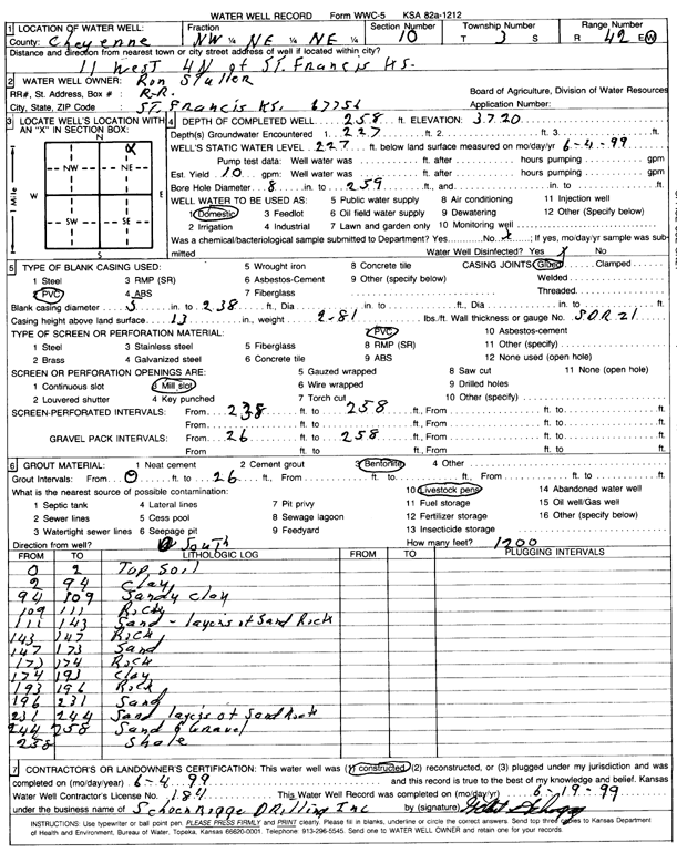
Specific Water Well Detail |
|
|
| Location Info | |||
| Owner: Stuller, Ron | Status: Constructed | ||
| Location: T3S, R42W, Sec. 10, NW NE NE | County: Cheyenne | ||
| Directions: from St. Francis, 11 mi W and 4 mi N | |||
| Latitude: 39.8133858 | Longitude: -102.0152974 | Datum NAD 27 | |
| Latitude: 39.8133783 | Longitude: -102.0157592 | Datum NAD 83 | |
| Longitude and latitude calculated by Survey from township-range-section-quarter calls. Only good to within the quarter call accuracy. | |||
| View well on interactive map | |||
| General Info | ||
| Well Depth: 258 ft. | Elevation: ft. | |
| Static Water Level: 227 ft. | Est. Yield: gpm. | |
| Comp. Date: 04-Jun-1999 | Well Use: Domestic | |
| DWR Applic. #: | Other ID: | |
| Driller Info | ||
| Driller: Schoenrogge Drilling, Inc. | License #: 184 | |
| Scanned Form | View scan |
|
Chemical Sample Submitted?:
Water Well disinfected?: | ||
| Casing Info | ||
| Casing Type:
Casing Joints: |
Diam: in. to ft | |
| Casing height above land surface: in
Casing Weight: lbs/ft Wall thickness or gauge no.: | ||
| Screen and Perforation Info | ||
| Screen Type: | Screen Openings: | |
| Screen-perforated intervals | From: ft to ft | |
| Gravel pack intervals | From: ft to ft | |
| Grout Info | ||
| Grout used: | From: to ft | |
| Source of Possible Contamination | ||
| Source: | ||
| Direction from well: | Distance: ft | |
| Lithologic Log
(Log data entered by KGS.) | ||
| From: 0 ft. to 2 ft. | Topsoil | |
| From: 2 ft. to 94 ft. | Clay | |
| From: 94 ft. to 109 ft. | Sandy clay | |
| From: 109 ft. to 111 ft. | Rock | |
| From: 111 ft. to 143 ft. | Sand, layers of sand rock | |
| From: 143 ft. to 147 ft. | Rock | |
| From: 147 ft. to 173 ft. | Sand | |
| From: 173 ft. to 174 ft. | Rock | |
| From: 174 ft. to 193 ft. | Clay | |
| From: 193 ft. to 196 ft. | Rock | |
| From: 196 ft. to 231 ft. | Sand | |
| From: 231 ft. to 244 ft. | Sand, layers of sand rock | |
| From: 244 ft. to 257 ft. | Sand and gravel | |
| From: 258 ft. to ft. | Shale | |