|
|
|
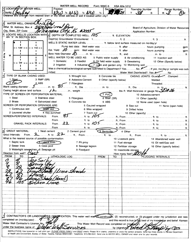
Specific Water Well Detail |
|
|
| Location Info | |||
| Owner: Ray, Chris | Status: Constructed | ||
| Location: T34S, R3E, Sec. 24, NW NW NW | County: Cowley | ||
| Directions: | |||
| Latitude: 37.0844161 | Longitude: -97.0568074 | Datum NAD 27 | |
| Latitude: 37.0844447 | Longitude: -97.0571235 | Datum NAD 83 | |
| Longitude and latitude calculated by Survey from township-range-section-quarter calls. Only good to within the quarter call accuracy. | |||
| View well on interactive map | |||
| General Info | ||
| Well Depth: 105 ft. | Elevation: ft. | |
| Static Water Level: ft. | Est. Yield: 10 gpm. | |
| Comp. Date: 08-Apr-1999 | Well Use: Domestic, Lawn and Garden | |
| DWR Applic. #: | Other ID: | |
| Driller Info | ||
| Driller: Robert L. Sharp Water Well Services | License #: 464 | |
| Scanned Form | View scan |
|
Chemical Sample Submitted?:
Water Well disinfected?: | ||
| Casing Info | ||
| Casing Type:
Casing Joints: |
Diam: in. to ft | |
| Casing height above land surface: in
Casing Weight: lbs/ft Wall thickness or gauge no.: | ||
| Screen and Perforation Info | ||
| Screen Type: | Screen Openings: | |
| Screen-perforated intervals | From: ft to ft | |
| Gravel pack intervals | From: ft to ft | |
| Grout Info | ||
| Grout used: | From: to ft | |
| Source of Possible Contamination | ||
| Source: | ||
| Direction from well: | Distance: ft | |
| Lithologic Log
(Log data entered by KGS.) | ||
| From: 0 ft. to 4 ft. | top soil | |
| From: 4 ft. to 8 ft. | brown clay | |
| From: 8 ft. to 28 ft. | sandy clay | |
| From: 28 ft. to 63 ft. | gray shale with limestone streaks | |
| From: 63 ft. to 87 ft. | limestone | |
| From: 87 ft. to 96 ft. | gray shale, hard | |
| From: 96 ft. to 105 ft. | broken limestone | |