|
|
|
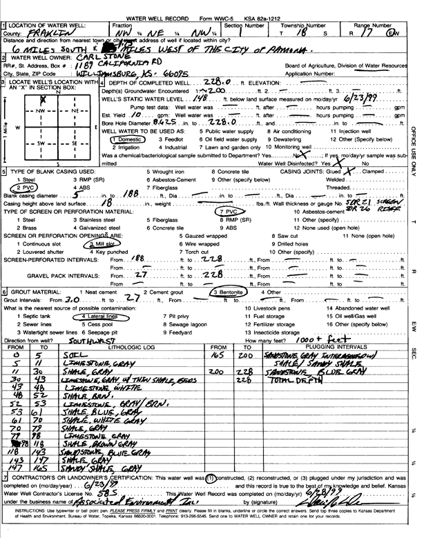
Specific Water Well Detail |
|
|
| Location Info | |||
| Owner: Stone, Carl | Status: Constructed | ||
| Location: T18S, R17E, Sec. 1, NW NE NW | County: Franklin | ||
| Directions: from Pomona, 6 mi S and 1.75 mi W | |||
| Latitude: 38.520422 | Longitude: -95.4839648 | Datum NAD 27 | |
| Latitude: 38.5204348 | Longitude: -95.484223 | Datum NAD 83 | |
| Longitude and latitude calculated by Survey from township-range-section-quarter calls. Only good to within the quarter call accuracy. | |||
| View well on interactive map | |||
| General Info | ||
| Well Depth: 228 ft. | Elevation: ft. | |
| Static Water Level: 148 ft. | Est. Yield: 10 gpm. | |
| Comp. Date: 23-Jun-1999 | Well Use: Domestic | |
| DWR Applic. #: | Other ID: | |
| Driller Info | ||
| Driller: Associated Environmental, Inc. | License #: 585 | |
| Scanned Form | View scan |
|
Chemical Sample Submitted?:
Water Well disinfected?: | ||
| Casing Info | ||
| Casing Type:
Casing Joints: |
Diam: in. to ft | |
| Casing height above land surface: in
Casing Weight: lbs/ft Wall thickness or gauge no.: | ||
| Screen and Perforation Info | ||
| Screen Type: | Screen Openings: | |
| Screen-perforated intervals | From: ft to ft | |
| Gravel pack intervals | From: ft to ft | |
| Grout Info | ||
| Grout used: | From: to ft | |
| Source of Possible Contamination | ||
| Source: | ||
| Direction from well: | Distance: ft | |
| Lithologic Log
(Log data entered by KGS.) | ||
| From: 0 ft. to 5 ft. | Soil | |
| From: 5 ft. to 11 ft. | Limestone, gray | |
| From: 11 ft. to 30 ft. | Shale, gray | |
| From: 30 ft. to 43 ft. | Limestone, gray with thin shale beds | |
| From: 43 ft. to 48 ft. | Limestone, white | |
| From: 48 ft. to 52 ft. | Shale, brown | |
| From: 52 ft. to 53 ft. | Limestone, gray/brown | |
| From: 53 ft. to 61 ft. | Shale, blue, gray | |
| From: 61 ft. to 70 ft. | Shale, white gray | |
| From: 70 ft. to 79 ft. | Shale, gray | |
| From: 79 ft. to 98 ft. | Limestone, gray | |
| From: 98 ft. to 118 ft. | Shale, brown gray | |
| From: 118 ft. to 143 ft. | Sandstone, blue gray | |
| From: 143 ft. to 147 ft. | Shale, gray | |
| From: 147 ft. to 165 ft. | Sandy shale, gray | |
| From: 165 ft. to 200 ft. | Sandstone, gray; interbedded with shale and sandy shale | |
| From: 200 ft. to 228 ft. | Sandstone, blue gray | |