|
|
|
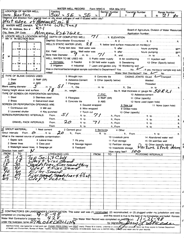
Specific Water Well Detail |
|
|
| Location Info | |||
| Owner: Whitney, Vernon | Status: Constructed | ||
| Location: T1S, R21W, Sec. 18, SW SE SE | County: Norton | ||
| Directions: W edge of Almena & 5 mi N | |||
| Latitude: 39.9589734 | Longitude: -99.7230501 | Datum NAD 27 | |
| Latitude: 39.9589808 | Longitude: -99.7234421 | Datum NAD 83 | |
| Longitude and latitude calculated by Survey from township-range-section-quarter calls. Only good to within the quarter call accuracy. | |||
| View well on interactive map | |||
| General Info | ||
| Well Depth: 71 ft. | Elevation: ft. | |
| Static Water Level: 28 ft. | Est. Yield: gpm. | |
| Comp. Date: 08-Sep-1998 | Well Use: Domestic | |
| DWR Applic. #: | Other ID: | |
| Driller Info | ||
| Driller: Leo J. Stalder Drilling | License #: 428 | |
| Scanned Form | View scan |
|
Chemical Sample Submitted?:
Water Well disinfected?: | ||
| Casing Info | ||
| Casing Type:
Casing Joints: |
Diam: in. to ft | |
| Casing height above land surface: in
Casing Weight: lbs/ft Wall thickness or gauge no.: | ||
| Screen and Perforation Info | ||
| Screen Type: | Screen Openings: | |
| Screen-perforated intervals | From: ft to ft | |
| Gravel pack intervals | From: ft to ft | |
| Grout Info | ||
| Grout used: | From: to ft | |
| Source of Possible Contamination | ||
| Source: | ||
| Direction from well: | Distance: ft | |
| Lithologic Log
(Log data entered by KGS.) | ||
| From: 0 ft. to 15 ft. | topsoil and clay | |
| From: 15 ft. to 18 ft. | clay and fine sand | |
| From: 18 ft. to 30 ft. | sandstone, fine sand thru | |
| From: 30 ft. to 40 ft. | clay and fine sand | |
| From: 40 ft. to 60 ft. | fine sand | |
| From: 60 ft. to 69 ft. | fine sand, sandstone and flint | |
| From: 69 ft. to 71 ft. | clay and ochre | |