|
|
|
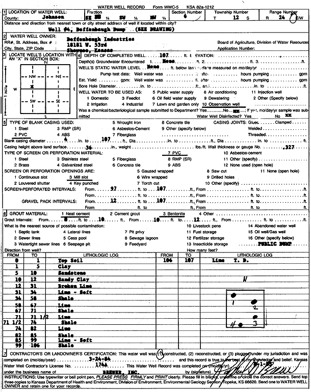
Specific Water Well Detail |
|
|
| Location Info | |||
| Owner: Deffenbaugh Industries | Status: Constructed | ||
| Location: T12S, R24E, Sec. 6, SE SW NW | County: Johnson | ||
| Directions: Deffenbaugh dump | |||
| Latitude: 39.0373478 | Longitude: -94.7939674 | Datum NAD 27 | |
| Latitude: 39.0373527 | Longitude: -94.7942071 | Datum NAD 83 | |
| Longitude and latitude calculated by Survey from township-range-section-quarter calls. Only good to within the quarter call accuracy. | |||
| View well on interactive map | |||
| General Info | ||
| Well Depth: 107 ft. | Elevation: ft. | |
| Static Water Level: ft. | Est. Yield: gpm. | |
| Comp. Date: 24-Mar-1984 | Well Use: Monitoring well/observation/piezometer | |
| DWR Applic. #: | Other ID: well 4 | |
| Driller Info | ||
| Driller: Raphael Breuer, Inc. | License #: 174 | |
| Scanned Form | View scan |
|
Chemical Sample Submitted?: No
Water Well disinfected?: | ||
| Ground water encountered: 0 ft. , 0 ft. , 0 ft. | ||
| Pump test data: Well water was 0 ft after 0 hours pumping 0 gpm | ||
| Casing Info | ||
| Casing Type: PVC
Casing Joints: |
Diam: 4 in. to 107 ft
Diam: 0 in. to 0 ft Diam: 0 in. to 0 ft | |
| Casing height above land surface: in
Casing Weight: lbs/ft Wall thickness or gauge no.: | ||
| Screen and Perforation Info | ||
| Screen Type: PVC | Screen Openings: Mill slot | |
| Screen-perforated intervals | From: 97 ft to 107 ft
From: 0 ft to 0 ft From: 0 ft to 0 ft | |
| Gravel pack intervals | From: ft to ft | |
| Grout Info | ||
| Grout used: Neat cement | From: 0 to 10 ft
From: 10 to 12 ft From: 0 to 0 ft | |
| Source of Possible Contamination | ||
| Source: OTHER | ||
| Direction from well: | Distance: 0 ft | |
| Lithologic Log
(Log data entered by KGS.) | ||
| From: 0 ft. to 1 ft. | top soil | |
| From: 1 ft. to 5 ft. | clay | |
| From: 5 ft. to 10 ft. | sandstone | |
| From: 10 ft. to 12 ft. | sandy clay | |
| From: 12 ft. to 31 ft. | broken limestone | |
| From: 31 ft. to 34 ft. | limestone, soft | |
| From: 34 ft. to 58 ft. | shale | |
| From: 58 ft. to 67 ft. | limestone | |
| From: 67 ft. to 71 ft. | shale | |
| From: 71 ft. to 71.5 ft. | limestone | |
| From: 71.5 ft. to 74 ft. | shale | |
| From: 74 ft. to 82 ft. | limestone | |
| From: 82 ft. to 85 ft. | shale | |
| From: 85 ft. to 99 ft. | limestone, soft | |
| From: 99 ft. to 106 ft. | shale | |