|
|
|
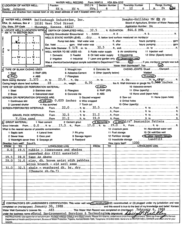
Specific Water Well Detail |
|
|
| Location Info | |||
| Owner: Deffenbaugh Industries | Status: Constructed | ||
| Location: T12S, R24E, Sec. 6, SE NW NW | County: Johnson | ||
| Directions: | |||
| Latitude: 39.0409618 | Longitude: -94.7939776 | Datum NAD 27 | |
| Latitude: 39.0409666 | Longitude: -94.7942174 | Datum NAD 83 | |
| Longitude and latitude calculated by Survey from township-range-section-quarter calls. Only good to within the quarter call accuracy. | |||
| View well on interactive map | |||
| General Info | ||
| Well Depth: 32 ft. | Elevation: 844 ft. | |
| Static Water Level: ft. | Est. Yield: gpm. | |
| Comp. Date: 30-Jan-1988 | Well Use: Monitoring well/observation/piezometer | |
| DWR Applic. #: | Other ID: MW 9 | |
| Driller Info | ||
| Driller: Defenbaugh Industries, Inc. (T.E.S.T.) | License #: 483 | |
| Scanned Form | View scan |
|
Chemical Sample Submitted?: No
Water Well disinfected?: | ||
| Ground water encountered: 0 ft. , 0 ft. , 0 ft. | ||
| Pump test data: Well water was 0 ft after 0 hours pumping 0 gpm | ||
| Casing Info | ||
| Casing Type: PVC
Casing Joints: |
Diam: 2 in. to 22 ft
Diam: 0 in. to 0 ft Diam: 0 in. to 0 ft | |
| Casing height above land surface: in
Casing Weight: lbs/ft Wall thickness or gauge no.: | ||
| Screen and Perforation Info | ||
| Screen Type: PVC | Screen Openings: Mill slot | |
| Screen-perforated intervals | From: 22 ft to 32 ft
From: 0 ft to 0 ft From: 0 ft to 0 ft | |
| Gravel pack intervals | From: ft to ft | |
| Grout Info | ||
| Grout used: Bentonite, | From: 0 to 17 ft
From: 0 to 0 ft From: 0 to 0 ft | |
| Source of Possible Contamination | ||
| Source: OTHER | ||
| Direction from well: | Distance: 0 ft | |
| Lithologic Log
(Log data entered by KGS.) | ||
| From: 0 ft. to 19.5 ft. | rubble, limestone and shale reworked, dry (fill material) | |
| From: 19.5 ft. to 28 ft. | rubble, limestone and shale reworked, dry (fill material) | |
| From: 28 ft. to 31 ft. | clay, dark brown, moist, with pebbles, tree branch, old soil zone | |
| From: 31 ft. to 32.3 ft. | weathered shale, dark brown, dry (Chanute Shale?) | |