|
|
|
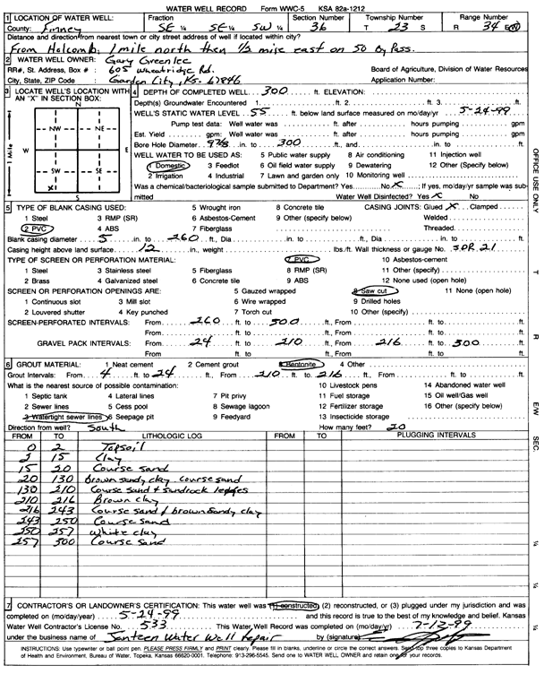
Specific Water Well Detail |
|
|
| Location Info | |||
| Owner: Greenlee, Gary | Status: Constructed | ||
| Location: T23S, R34W, Sec. 36, SE SE SW | County: Finney | ||
| Directions: from Holcomb, 1 mi N, 0.5 mi E on 50 By Pass | |||
| Latitude: 38.0044186 | Longitude: -101.0031864 | Datum NAD 27 | |
| Latitude: 38.0044428 | Longitude: -101.0036308 | Datum NAD 83 | |
| Longitude and latitude calculated by Survey from township-range-section-quarter calls. Only good to within the quarter call accuracy. | |||
| View well on interactive map | |||
| General Info | ||
| Well Depth: 300 ft. | Elevation: ft. | |
| Static Water Level: 55 ft. | Est. Yield: gpm. | |
| Comp. Date: 24-May-1999 | Well Use: Domestic | |
| DWR Applic. #: | Other ID: | |
| Driller Info | ||
| Driller: Jantzen Water Well | License #: 533 | |
| Scanned Form | View scan |
|
Chemical Sample Submitted?:
Water Well disinfected?: | ||
| Casing Info | ||
| Casing Type:
Casing Joints: |
Diam: in. to ft | |
| Casing height above land surface: in
Casing Weight: lbs/ft Wall thickness or gauge no.: | ||
| Screen and Perforation Info | ||
| Screen Type: | Screen Openings: | |
| Screen-perforated intervals | From: ft to ft | |
| Gravel pack intervals | From: ft to ft | |
| Grout Info | ||
| Grout used: | From: to ft | |
| Source of Possible Contamination | ||
| Source: | ||
| Direction from well: | Distance: ft | |
| Lithologic Log
(Log data entered by KGS.) | ||
| From: 0 ft. to 2 ft. | topsoil | |
| From: 2 ft. to 15 ft. | clay | |
| From: 15 ft. to 20 ft. | coarse sand | |
| From: 20 ft. to 130 ft. | brown sandy clay, coarse sand | |
| From: 130 ft. to 210 ft. | coarse sand and sandrock ledges | |
| From: 210 ft. to 216 ft. | brown clay | |
| From: 216 ft. to 243 ft. | coarse sand and brown sandy clay | |
| From: 243 ft. to 250 ft. | coarse sand | |
| From: 250 ft. to 257 ft. | white clay | |
| From: 257 ft. to 300 ft. | coarse sand | |