|
|
|
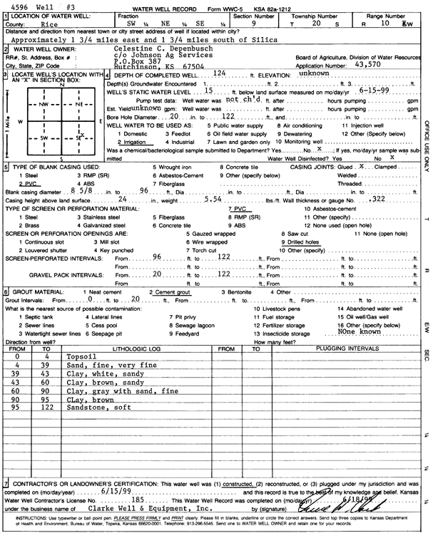
Specific Water Well Detail |
|
|
| Location Info | |||
| Owner: Depenbusch, Celestine C. | Status: Constructed | ||
| Location: T20S, R10W, Sec. 9, SW NE SE | County: Rice | ||
| Directions: from Silica: 1.75 mi E, 1.75 mi S | |||
| Latitude: 38.3230264 | Longitude: -98.4276014 | Datum NAD 27 | |
| Latitude: 38.323038 | Longitude: -98.42795 | Datum NAD 83 | |
| Longitude and latitude calculated by Survey from township-range-section-quarter calls. Only good to within the quarter call accuracy. | |||
| View well on interactive map | |||
| General Info | ||
| Well Depth: 124 ft. | Elevation: ft. | |
| Static Water Level: 15 ft. | Est. Yield: gpm. | |
| Comp. Date: 15-Jun-1999 | Well Use: Irrigation | |
| DWR Applic. #: 43570 | Other ID: Well 3 | |
| Links | |
| No Wizard information available. | |
| View info from WIMAS Water Right Data base... | |
| Driller Info | ||
| Driller: Clarke Well and Equipment, Inc. | License #: 185 | |
| Scanned Form | View scan |
|
Chemical Sample Submitted?:
Water Well disinfected?: | ||
| Casing Info | ||
| Casing Type:
Casing Joints: |
Diam: in. to ft | |
| Casing height above land surface: in
Casing Weight: lbs/ft Wall thickness or gauge no.: | ||
| Screen and Perforation Info | ||
| Screen Type: | Screen Openings: | |
| Screen-perforated intervals | From: ft to ft | |
| Gravel pack intervals | From: ft to ft | |
| Grout Info | ||
| Grout used: | From: to ft | |
| Source of Possible Contamination | ||
| Source: | ||
| Direction from well: | Distance: ft | |
| Lithologic Log
(Log data entered by KGS.) | ||
| From: 0 ft. to 4 ft. | top soil | |
| From: 4 ft. to 39 ft. | fine-very fine sand | |
| From: 39 ft. to 43 ft. | sandy clay, white | |
| From: 43 ft. to 60 ft. | sandy clay, brown | |
| From: 60 ft. to 90 ft. | clay, gray, with fine sand | |
| From: 90 ft. to 95 ft. | clay, brown | |
| From: 95 ft. to 122 ft. | sandstone, soft | |