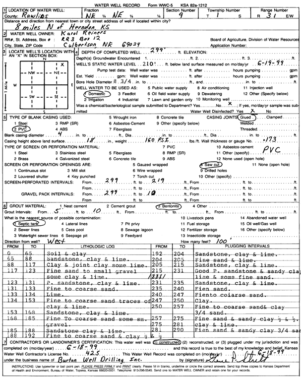
KGS Home Page Water Well Data base Specific Water Well Detail
Water Resources

Well T1S, R31W, Sec. 9, NE NE, Action: Constructed

Location Info
Owner: Reiners, Karol Status: Constructed
Location: T1S, R31W, Sec. 9, NE NE County: Rawlins
Directions: from Herndon, 8 mi N
Latitude: 39.9858016 Longitude: -100.7971136 Datum NAD 27
Latitude: 39.985805 Longitude: -100.7975452 Datum NAD 83
Longitude and latitude calculated by Survey from township-range-section-quarter calls. Only good to within the quarter call accuracy.
View well on interactive map This link will create a new window and display an interactive map of this well and its neighbors.
General Info
Well Depth: 299 ft. Elevation: ft.
Static Water Level: 210 ft. Est. Yield: gpm.
Comp. Date: 18-Jun-1999 Well Use: Domestic
DWR Applic. #: Other ID:
Driller Info
Driller: Burton Well Drilling, Inc. License #: 425
Scanned Form
View form(s) on screen Download scan(s)
The download files contain one or more TIFF images compressed into a ZIP archive. Your browser may be already set up to decompress these files. The TIFFs are 300 dpi archival-quality scans of the WWC5 forms and can be viewed by software like Adobe PhotoShop.
Chemical Sample Submitted?:
Water Well disinfected?:
Casing Info
Casing Type:
Casing Joints:
Diam: in. to ft
Casing height above land surface: in
Casing Weight: lbs/ft
Wall thickness or gauge no.:
Screen and Perforation Info
Screen Type: Screen Openings:
Screen-perforated intervals From: ft to ft
Gravel pack intervals From: ft to ft
Grout Info
Grout used: From: to ft
Source of Possible Contamination
Source:
Direction from well: Distance: ft
Lithologic Log
(Log data entered by KGS.)
From: 0 ft. to 65 ft. soil and clay
From: 65 ft. to 88 ft. sandstone, clay, and lime
From: 88 ft. to 117 ft. clay and joint clay, some lime
From: 117 ft. to 123 ft. fine sand to small gravel, some clay and lime
From: 123 ft. to 131 ft. P. sandstone, clay and lime
From: 131 ft. to 133 ft. fine to coarse sand
From: 133 ft. to 134 ft. lime
From: 134 ft. to 153 ft. fine to coarse sand, traces of clay and lime
From: 153 ft. to 168 ft. sandstone, clay, and lime
From: 168 ft. to 185 ft. fine to coarse sand, some small gravel
From: 185 ft. to 188 ft. sandstone, clay, and lime
From: 188 ft. to 192 ft. fine to coarse sand and clay
From: 192 ft. to 204 ft. sandstone, clay, and lime
From: 204 ft. to 205 ft. fine sand and lime
From: 205 ft. to 215 ft. sandstone, clay, and lime
From: 215 ft. to 231 ft. good P. sandstone and sandy clay, lime, and some fine sand
From: 231 ft. to 235 ft. sandstone, clay, and lime
From: 235 ft. to 240 ft. fine sand
From: 240 ft. to 247 ft. fine to coarse sand
From: 247 ft. to 250 ft. clay
From: 250 ft. to 257 ft. fine to coarse sand and clay
From: 257 ft. to 275 ft. fine sand and sandy clay
From: 275 ft. to 281 ft. clay and lime
From: 281 ft. to 290 ft. fine sand and sandy clay

Kansas Geological Survey
Comments to webadmin@kgs.ku.edu
URL=http://www.kgs.ku.edu/Magellan/WaterWell/index.html
Display Programs Updated July 2, 2014
Data added continuously.