|
|
|
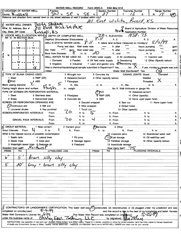
Specific Water Well Detail |
|
|
| Location Info | |||
| Owner: Thrift Station | Status: Constructed | ||
| Location: T13S, R14W, Sec. 27, SW SE SE | County: Russell | ||
| Directions: 211 E Wichita, Russell | |||
| Latitude: 38.8865073 | Longitude: -98.8575586 | Datum NAD 27 | |
| Latitude: 38.8864724 | Longitude: -98.8579202 | Datum NAD 83 | |
| Longitude and latitude calculated by Survey from township-range-section-quarter calls. Only good to within the quarter call accuracy. | |||
| View well on interactive map | |||
| General Info | ||
| Well Depth: 20 ft. | Elevation: 1838.73 ft. | |
| Static Water Level: 8.11 ft. | Est. Yield: gpm. | |
| Comp. Date: 04-May-1999 | Well Use: Monitoring well/observation/piezometer | |
| DWR Applic. #: | Other ID: MW 9 | |
| Driller Info | ||
| Driller: Shirly Env. Testing LLC | License #: 634 | |
| Scanned Form | View scan |
|
Chemical Sample Submitted?:
Water Well disinfected?: | ||
| Casing Info | ||
| Casing Type:
Casing Joints: |
Diam: in. to ft | |
| Casing height above land surface: in
Casing Weight: lbs/ft Wall thickness or gauge no.: | ||
| Screen and Perforation Info | ||
| Screen Type: | Screen Openings: | |
| Screen-perforated intervals | From: ft to ft | |
| Gravel pack intervals | From: ft to ft | |
| Grout Info | ||
| Grout used: | From: to ft | |
| Source of Possible Contamination | ||
| Source: | ||
| Direction from well: | Distance: ft | |
| Lithologic Log
(Log data entered by KGS.) | ||
| From: .5 ft. to 5 ft. | brown silty clay | |
| From: 5 ft. to 20 ft. | gray and brown silty clay | |