|
|
|
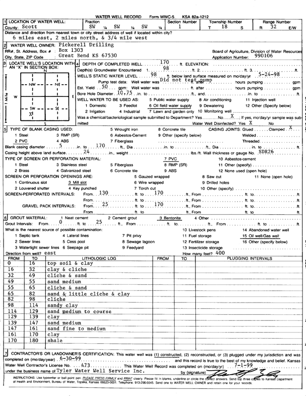
Specific Water Well Detail |
|
|
| Location Info | |||
| Owner: Pickrell Drilling Co. | Status: Constructed | ||
| Location: T18S, R32W, Sec. 1, SW SW SW | County: Scott | ||
| Directions: from Scott City, 6 mi E, 2 mi N, .75 mi W | |||
| Latitude: 38.5127996 | Longitude: -100.8132803 | Datum NAD 27 | |
| Latitude: 38.5128176 | Longitude: -100.8137066 | Datum NAD 83 | |
| Longitude and latitude calculated by Survey from township-range-section-quarter calls. Only good to within the quarter call accuracy. | |||
| View well on interactive map | |||
| General Info | ||
| Well Depth: 170 ft. | Elevation: ft. | |
| Static Water Level: 98 ft. | Est. Yield: 50 gpm. | |
| Comp. Date: 30-Jun-1999 | Well Use: Oil Field Water Supply | |
| DWR Applic. #: 990106 | Other ID: | |
| Links | |
| No Wizard information available. | |
| View info from WIMAS Water Right Data base... | |
| Driller Info | ||
| Driller: Tyler Water Well, Inc. | License #: 473 | |
| Scanned Form | View scan |
|
Chemical Sample Submitted?:
Water Well disinfected?: | ||
| Casing Info | ||
| Casing Type:
Casing Joints: |
Diam: in. to ft | |
| Casing height above land surface: in
Casing Weight: lbs/ft Wall thickness or gauge no.: | ||
| Screen and Perforation Info | ||
| Screen Type: | Screen Openings: | |
| Screen-perforated intervals | From: ft to ft | |
| Gravel pack intervals | From: ft to ft | |
| Grout Info | ||
| Grout used: | From: to ft | |
| Source of Possible Contamination | ||
| Source: | ||
| Direction from well: | Distance: ft | |
| Lithologic Log
(Log data entered by KGS.) | ||
| From: 0 ft. to 16 ft. | Top soil and clay | |
| From: 16 ft. to 32 ft. | Clay and caliche | |
| From: 32 ft. to 49 ft. | Caliche and sand | |
| From: 49 ft. to 55 ft. | Sand, medium | |
| From: 55 ft. to 65 ft. | Caliche and sand | |
| From: 65 ft. to 82 ft. | Sand and little caliche and clay | |
| From: 82 ft. to 98 ft. | Caliche | |
| From: 98 ft. to 114 ft. | Sandy clay | |
| From: 114 ft. to 129 ft. | Sand, medium to coarse | |
| From: 129 ft. to 139 ft. | Clay | |
| From: 139 ft. to 147 ft. | Sand, medium | |
| From: 147 ft. to 161 ft. | Sand, fine to medium | |
| From: 161 ft. to 170 ft. | Clay | |
| From: 170 ft. to 180 ft. | Shale | |