|
|
|
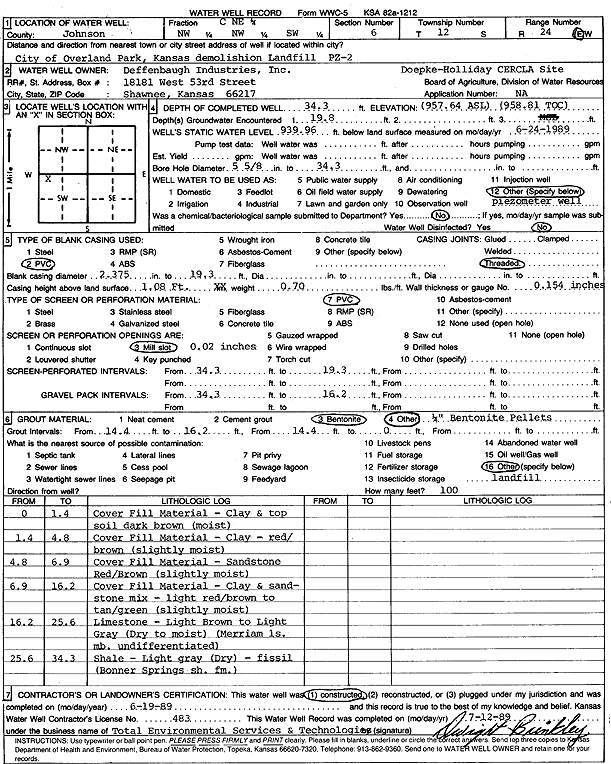
Specific Water Well Detail |
|
|
| Location Info | |||
| Owner: Deffenbaugh Industries | Status: Constructed | ||
| Location: T12S, R24E, Sec. 6, NW NW SW | County: Johnson | ||
| Directions: City of Overland Park demolition landfill | |||
| Latitude: 39.0355315 | Longitude: -94.7961559 | Datum NAD 27 | |
| Latitude: 39.0355364 | Longitude: -94.7963957 | Datum NAD 83 | |
| Longitude and latitude calculated by Survey from township-range-section-quarter calls. Only good to within the quarter call accuracy. | |||
| View well on interactive map | |||
| General Info | ||
| Well Depth: 34 ft. | Elevation: 957.64 ft. | |
| Static Water Level: 17.68 ft. | Est. Yield: gpm. | |
| Comp. Date: 19-Jun-1989 | Well Use: Monitoring well/observation/piezometer | |
| DWR Applic. #: | Other ID: PZ 2 | |
| Driller Info | ||
| Driller: Defenbaugh Industries, Inc. (T.E.S.T.) | License #: 483 | |
| Scanned Form | View scan |
|
Chemical Sample Submitted?: No
Water Well disinfected?: | ||
| Ground water encountered: 19 ft. , 0 ft. , 0 ft. | ||
| Pump test data: Well water was 0 ft after 0 hours pumping 0 gpm | ||
| Casing Info | ||
| Casing Type: PVC
Casing Joints: |
Diam: 2 in. to 19 ft
Diam: 0 in. to 0 ft Diam: 0 in. to 0 ft | |
| Casing height above land surface: in
Casing Weight: lbs/ft Wall thickness or gauge no.: | ||
| Screen and Perforation Info | ||
| Screen Type: PVC | Screen Openings: Mill slot | |
| Screen-perforated intervals | From: 34 ft to 19 ft
From: 0 ft to 0 ft From: 0 ft to 0 ft | |
| Gravel pack intervals | From: ft to ft | |
| Grout Info | ||
| Grout used: Bentonite, | From: 14 to 16 ft
From: 0 to 14 ft From: 0 to 0 ft | |
| Source of Possible Contamination | ||
| Source: OTHER | ||
| Direction from well: | Distance: 0 ft | |
| Lithologic Log
(Log data entered by KGS.) | ||
| From: 0 ft. to 1.4 ft. | fill material, clay and top soil, dark brown, moist | |
| From: 1.4 ft. to 4.8 ft. | fill material, clay, red brown, slightly moist | |
| From: 4.8 ft. to 6.9 ft. | fill material, sandstone, red brown, slightly moist | |
| From: 6.9 ft. to 16.2 ft. | fill material, clay and sandstone mix, light red brown to tan green, slightly moist | |
| From: 16.2 ft. to 25.6 ft. | limestone, light brown to light gray, dry to moist, (Merriam Limestone Mbr) | |
| From: 25.6 ft. to 34.3 ft. | shale, light gray, dry, fissile (Bonner Springs Shale) | |