|
|
|
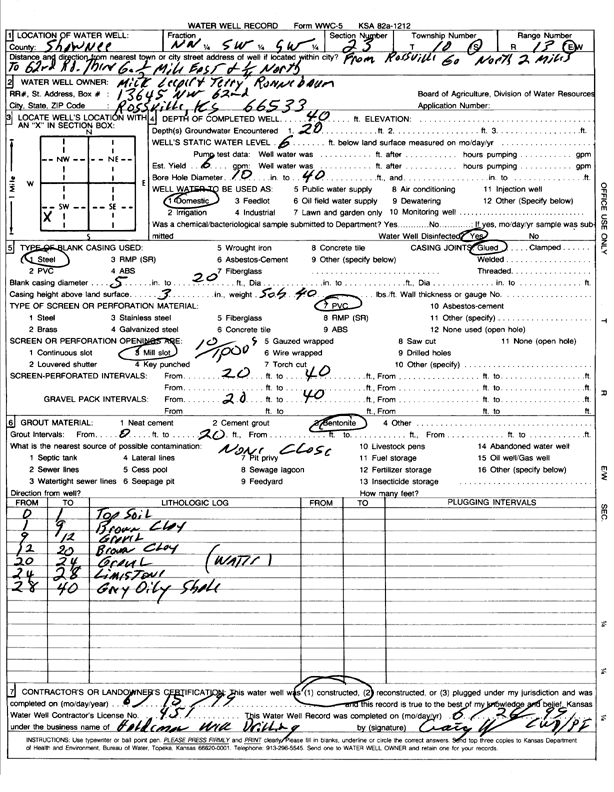
Specific Water Well Detail |
|
|
| Location Info | |||
| Owner: Leeper, Mick/Ronnebaum, Terry | Status: Constructed | ||
| Location: T10S, R13E, Sec. 23, NW SW SW | County: Shawnee | ||
| Directions: from Rossville: N 2 mi to 63rd, then go 1 mi E and .25 mi N | |||
| Latitude: 39.1614254 | Longitude: -95.9413724 | Datum NAD 27 | |
| Latitude: 39.1614236 | Longitude: -95.9416397 | Datum NAD 83 | |
| Longitude and latitude calculated by Survey from township-range-section-quarter calls. Only good to within the quarter call accuracy. | |||
| View well on interactive map | |||
| General Info | ||
| Well Depth: 40 ft. | Elevation: ft. | |
| Static Water Level: 6 ft. | Est. Yield: 6 gpm. | |
| Comp. Date: 15-Jun-1999 | Well Use: Domestic | |
| DWR Applic. #: | Other ID: | |
| Driller Info | ||
| Driller: Holdeman Well Drilling | License #: 451 | |
| Scanned Form | View scan |
|
Chemical Sample Submitted?:
Water Well disinfected?: | ||
| Casing Info | ||
| Casing Type:
Casing Joints: |
Diam: in. to ft | |
| Casing height above land surface: in
Casing Weight: lbs/ft Wall thickness or gauge no.: | ||
| Screen and Perforation Info | ||
| Screen Type: | Screen Openings: | |
| Screen-perforated intervals | From: ft to ft | |
| Gravel pack intervals | From: ft to ft | |
| Grout Info | ||
| Grout used: | From: to ft | |
| Source of Possible Contamination | ||
| Source: | ||
| Direction from well: | Distance: ft | |
| Lithologic Log
(Log data entered by KGS.) | ||
| From: 0 ft. to 1 ft. | top soil | |
| From: 1 ft. to 9 ft. | brown clay | |
| From: 9 ft. to 12 ft. | gravel | |
| From: 12 ft. to 20 ft. | brown clay | |
| From: 20 ft. to 24 ft. | gravel | |
| From: 24 ft. to 28 ft. | limestone | |
| From: 28 ft. to 40 ft. | gray oily shale | |