|
|
|
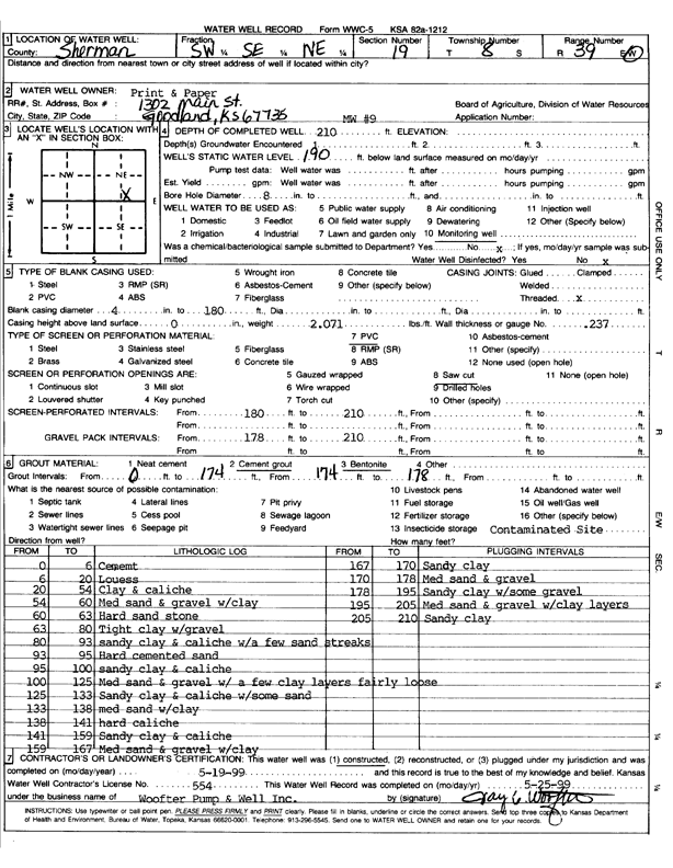
Specific Water Well Detail |
|
|
| Location Info | |||
| Owner: Prints and the Paper | Status: Constructed | ||
| Location: T8S, R39W, Sec. 19, SW SE NE | County: Sherman | ||
| Directions: | |||
| Latitude: 39.3448507 | Longitude: -101.7104513 | Datum NAD 27 | |
| Latitude: 39.3448505 | Longitude: -101.7109013 | Datum NAD 83 | |
| Longitude and latitude calculated by Survey from township-range-section-quarter calls. Only good to within the quarter call accuracy. | |||
| View well on interactive map | |||
| General Info | ||
| Well Depth: 210 ft. | Elevation: ft. | |
| Static Water Level: 190 ft. | Est. Yield: gpm. | |
| Comp. Date: 19-May-1999 | Well Use: Monitoring well/observation/piezometer | |
| DWR Applic. #: | Other ID: MW 9 | |
| Driller Info | ||
| Driller: Woofter Pump & Well, Inc. | License #: 554 | |
| Scanned Form | View scan |
|
Chemical Sample Submitted?:
Water Well disinfected?: | ||
| Casing Info | ||
| Casing Type:
Casing Joints: |
Diam: in. to ft | |
| Casing height above land surface: in
Casing Weight: lbs/ft Wall thickness or gauge no.: | ||
| Screen and Perforation Info | ||
| Screen Type: | Screen Openings: | |
| Screen-perforated intervals | From: ft to ft | |
| Gravel pack intervals | From: ft to ft | |
| Grout Info | ||
| Grout used: | From: to ft | |
| Source of Possible Contamination | ||
| Source: | ||
| Direction from well: | Distance: ft | |
| Lithologic Log
(Log data entered by KGS.) | ||
| From: 0 ft. to 6 ft. | Cement | |
| From: 6 ft. to 20 ft. | Loess | |
| From: 20 ft. to 54 ft. | Clay and caliche | |
| From: 54 ft. to 60 ft. | Medium sand and gravel with clay | |
| From: 60 ft. to 63 ft. | Hard sandstone | |
| From: 63 ft. to 80 ft. | Tight clay with gravel | |
| From: 80 ft. to 93 ft. | Sandy clay and caliche with a few sand streaks | |
| From: 93 ft. to 95 ft. | Hard cemented sand | |
| From: 95 ft. to 100 ft. | Sandy clay and caliche with some sand | |
| From: 100 ft. to 125 ft. | Medium sand and gravel with a few clay layers, fairly loose | |
| From: 125 ft. to 133 ft. | Sandy clay and caliche with some sand | |
| From: 133 ft. to 138 ft. | Medium sand with clay | |
| From: 138 ft. to 141 ft. | Hard caliche | |
| From: 141 ft. to 159 ft. | Sandy clay and caliche | |
| From: 159 ft. to 167 ft. | Medium sand and gravel with clay | |
| From: 167 ft. to 170 ft. | Sandy clay | |
| From: 170 ft. to 178 ft. | Medium sand and gravel | |
| From: 178 ft. to 195 ft. | Sandy clay with some gravel | |
| From: 195 ft. to 205 ft. | Medium sand and gravel with clay layers | |
| From: 205 ft. to 210 ft. | Sandy clay | |