|
|
|
Specific Water Well Detail |
|
|
| Location Info | |||
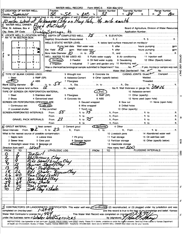
| Owner: McClasky, Floyd | Status: Constructed | ||
| Location: T34S, R2E, Sec. 32, SE SE NE | County: Sumner | ||
| Directions: from Arkansas City: 10 mi W on Hwy 166, .75 mi S | |||
| Latitude: 37.0505097 | Longitude: -97.2206981 | Datum NAD 27 | |
| Latitude: 37.0505375 | Longitude: -97.2210179 | Datum NAD 83 | |
| Longitude and latitude calculated by Survey from township-range-section-quarter calls. Only good to within the quarter call accuracy. | |||
| View well on interactive map | |||
| General Info | ||
| Well Depth: 75 ft. | Elevation: ft. | |
| Static Water Level: ft. | Est. Yield: 25 gpm. | |
| Comp. Date: 29-Jan-1999 | Well Use: Domestic | |
| DWR Applic. #: | Other ID: | |
| Driller Info | ||
| Driller: Robert L. Sharp Water Well Services | License #: 464 | |
| Scanned Form | View scan |
|
Chemical Sample Submitted?:
Water Well disinfected?: | ||
| Casing Info | ||
| Casing Type:
Casing Joints: |
Diam: in. to ft | |
| Casing height above land surface: in
Casing Weight: lbs/ft Wall thickness or gauge no.: | ||
| Screen and Perforation Info | ||
| Screen Type: | Screen Openings: | |
| Screen-perforated intervals | From: ft to ft | |
| Gravel pack intervals | From: ft to ft | |
| Grout Info | ||
| Grout used: | From: to ft | |
| Source of Possible Contamination | ||
| Source: | ||
| Direction from well: | Distance: ft | |
| Lithologic Log
(Log data entered by KGS.) | ||
| From: 0 ft. to 2 ft. | top soil | |
| From: 2 ft. to 8 ft. | red-brown clay | |
| From: 8 ft. to 9 ft. | fine sand and brown clay | |
| From: 9 ft. to 13 ft. | coarse sand and clay | |
| From: 13 ft. to 18 ft. | clay, red brown | |
| From: 18 ft. to 26 ft. | red shale and brown clay | |
| From: 26 ft. to 40 ft. | tan clay, soft | |
| From: 40 ft. to 58 ft. | tan shale and clay | |
| From: 58 ft. to 68 ft. | gray shale | |
| From: 68 ft. to 70 ft. | tan limestone | |
| From: 70 ft. to 75 ft. | soft clay and shale | |