|
|
|
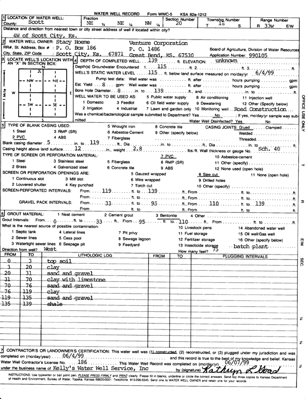
Specific Water Well Detail |
|
|
| Location Info | |||
| Owner: Hoeme, Stacy | Status: Constructed | ||
| Location: T18S, R33W, Sec. 20, NE NE NW | County: Scott | ||
| Directions: 4 mi W of Scott City | |||
| Latitude: 38.4813032 | Longitude: -100.9907808 | Datum NAD 27 | |
| Latitude: 38.481323 | Longitude: -100.9912104 | Datum NAD 83 | |
| Longitude and latitude calculated by Survey from township-range-section-quarter calls. Only good to within the quarter call accuracy. | |||
| View well on interactive map | |||
| General Info | ||
| Well Depth: 139 ft. | Elevation: ft. | |
| Static Water Level: 115 ft. | Est. Yield: gpm. | |
| Comp. Date: 04-Jun-1999 | Well Use: Road Construction | |
| DWR Applic. #: 990105 | Other ID: | |
| Links | |
| No Wizard information available. | |
| View info from WIMAS Water Right Data base... | |
| Driller Info | ||
| Driller: Kelly's Water Well Service, Inc. | License #: 186 | |
| Scanned Form | View scan |
|
Chemical Sample Submitted?:
Water Well disinfected?: | ||
| Casing Info | ||
| Casing Type:
Casing Joints: |
Diam: in. to ft | |
| Casing height above land surface: in
Casing Weight: lbs/ft Wall thickness or gauge no.: | ||
| Screen and Perforation Info | ||
| Screen Type: | Screen Openings: | |
| Screen-perforated intervals | From: ft to ft | |
| Gravel pack intervals | From: ft to ft | |
| Grout Info | ||
| Grout used: | From: to ft | |
| Source of Possible Contamination | ||
| Source: | ||
| Direction from well: | Distance: ft | |
| Lithologic Log
(Log data entered by KGS.) | ||
| From: 0 ft. to 3 ft. | Top soil | |
| From: 3 ft. to 20 ft. | Clay | |
| From: 20 ft. to 31 ft. | Sand and gravel | |
| From: 31 ft. to 70 ft. | Clay with limestone | |
| From: 70 ft. to 76 ft. | Sand and gravel | |
| From: 76 ft. to 119 ft. | Clay | |
| From: 119 ft. to 135 ft. | Sand and gravel | |
| From: 135 ft. to 139 ft. | Shale | |