|
|
|
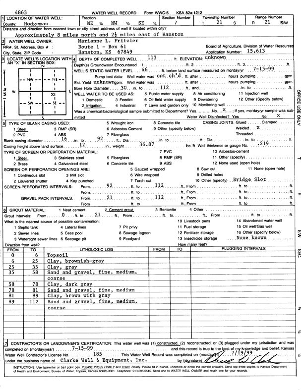
Specific Water Well Detail |
|
|
| Location Info | |||
| Owner: Fritzler, Marianne L. | Status: Constructed | ||
| Location: T21S, R21W, Sec. 7, NE NW SE | County: Hodgeman | ||
| Directions: from Hanston: 8 mi N, 2.5 mi E | |||
| Latitude: 38.2393244 | Longitude: -99.6673899 | Datum NAD 27 | |
| Latitude: 38.2393405 | Longitude: -99.6677886 | Datum NAD 83 | |
| Longitude and latitude calculated by Survey from township-range-section-quarter calls. Only good to within the quarter call accuracy. | |||
| View well on interactive map | |||
| General Info | ||
| Well Depth: 113 ft. | Elevation: ft. | |
| Static Water Level: 46 ft. | Est. Yield: gpm. | |
| Comp. Date: 15-Jul-1999 | Well Use: Irrigation | |
| DWR Applic. #: 15613 | Other ID: | |
| Links | |
| No Wizard information available. | |
| View info from WIMAS Water Right Data base... | |
| Driller Info | ||
| Driller: Clarke Well and Equipment, Inc. | License #: 185 | |
| Scanned Form | View scan |
|
Chemical Sample Submitted?:
Water Well disinfected?: | ||
| Casing Info | ||
| Casing Type:
Casing Joints: |
Diam: in. to ft | |
| Casing height above land surface: in
Casing Weight: lbs/ft Wall thickness or gauge no.: | ||
| Screen and Perforation Info | ||
| Screen Type: | Screen Openings: | |
| Screen-perforated intervals | From: ft to ft | |
| Gravel pack intervals | From: ft to ft | |
| Grout Info | ||
| Grout used: | From: to ft | |
| Source of Possible Contamination | ||
| Source: | ||
| Direction from well: | Distance: ft | |
| Lithologic Log
(Log data entered by KGS.) | ||
| From: 0 ft. to 6 ft. | top soil | |
| From: 6 ft. to 25 ft. | clay, brownish-gray | |
| From: 25 ft. to 35 ft. | clay, gray | |
| From: 35 ft. to 58 ft. | sand and gravel; fine, medium, coarse | |
| From: 58 ft. to 78 ft. | clay, dark gray | |
| From: 78 ft. to 81 ft. | sand and gravel, fine, medium | |
| From: 81 ft. to 89 ft. | clay, brown with gray | |
| From: 89 ft. to 112 ft. | sand and gravel; fine, medium, coarse | |