|
|
|
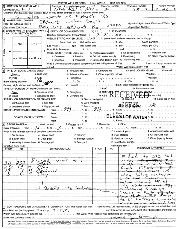
Specific Water Well Detail |
|
|
| Location Info | |||
| Owner: City of Elkhart Water Dept. | Status: Plugged | ||
| Location: T35S, R43W, Sec. 24, NW NW NW | County: Morton | ||
| Directions: from Elkhart, 1.5 mi W | |||
| Latitude: 36.9957368 | Longitude: -101.9516223 | Datum NAD 27 | |
| Latitude: 36.9957598 | Longitude: -101.9520685 | Datum NAD 83 | |
| Longitude and latitude calculated by Survey from township-range-section-quarter calls. Only good to within the quarter call accuracy. | |||
| View well on interactive map | |||
| General Info | ||
| Well Depth: 311 ft. | Elevation: ft. | |
| Static Water Level: 232 ft. | Est. Yield: gpm. | |
| Comp. Date: 07-Jun-1999 | Well Use: Public Water Supply | |
| DWR Applic. #: | Other ID: | |
| Driller Info | ||
| Driller: City of Elkhart | License #: | |
| Scanned Form | View scan |
| Casing Info | ||
|
Casing Type:
Diam: in. Casing height above land surface: in | ||
| Grout Info | ||
| Grout used: | From: to ft | |
| Source of Possible Contamination | ||
| Source: | ||
| Direction from well: | Distance: ft | |