|
|
|
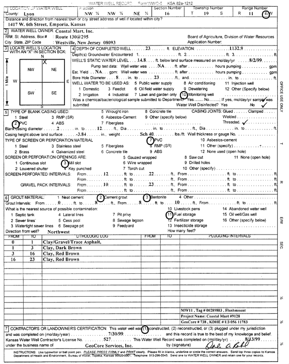
Specific Water Well Detail |
|
|
| Location Info | |||
| Owner: Coastal Mart, Inc. | Status: Constructed | ||
| Location: T19S, R11E, Sec. 16, NW NW NE | County: Lyon | ||
| Directions: 1417 W 6 St, Emporia (Tag 00289803) | |||
| Latitude: 38.4041052 | Longitude: -96.1972265 | Datum NAD 27 | |
| Latitude: 38.4041193 | Longitude: -96.1975007 | Datum NAD 83 | |
| Longitude and latitude calculated by Survey from township-range-section-quarter calls. Only good to within the quarter call accuracy. | |||
| View well on interactive map | |||
| General Info | ||
| Well Depth: 23 ft. | Elevation: 1132.9 ft. | |
| Static Water Level: 14.8 ft. | Est. Yield: gpm. | |
| Comp. Date: 30-Jul-1999 | Well Use: Monitoring well/observation/piezometer | |
| DWR Applic. #: | Other ID: MW 11 | |
| Driller Info | ||
| Driller: GeoCore Services Inc. | License #: 527 | |
| Scanned Form | View scan |
|
Chemical Sample Submitted?:
Water Well disinfected?: | ||
| Casing Info | ||
| Casing Type:
Casing Joints: |
Diam: in. to ft | |
| Casing height above land surface: in
Casing Weight: lbs/ft Wall thickness or gauge no.: | ||
| Screen and Perforation Info | ||
| Screen Type: | Screen Openings: | |
| Screen-perforated intervals | From: ft to ft | |
| Gravel pack intervals | From: ft to ft | |
| Grout Info | ||
| Grout used: | From: to ft | |
| Source of Possible Contamination | ||
| Source: | ||
| Direction from well: | Distance: ft | |
| Lithologic Log
(Log data entered by KGS.) | ||
| From: 0 ft. to 1 ft. | clay, gravel, and trace asphalt | |
| From: 1 ft. to 3 ft. | clay, dark brown | |
| From: 3 ft. to 16 ft. | clay, red brown | |
| From: 16 ft. to 23 ft. | clay, red brown | |