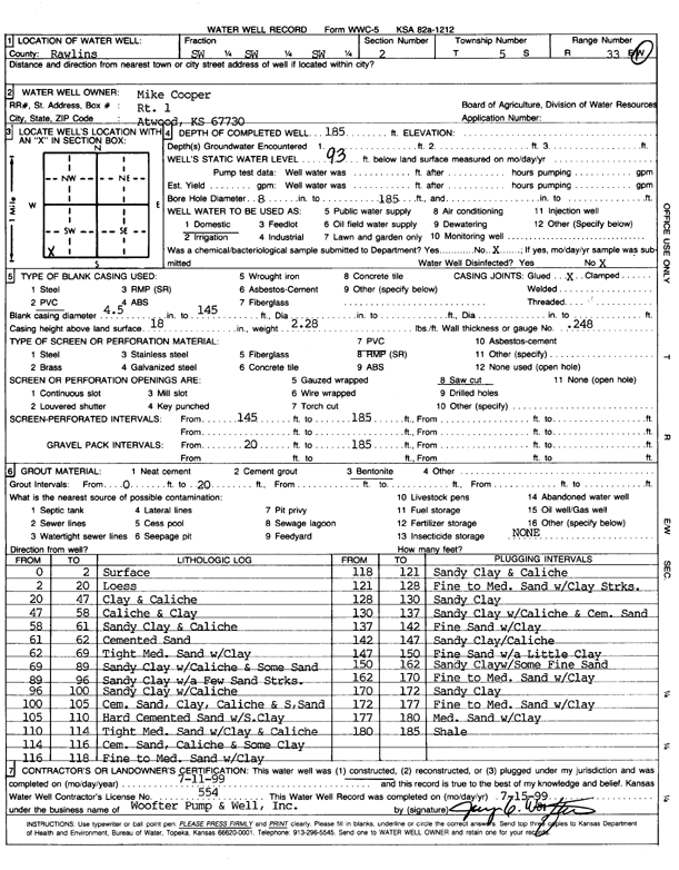
Lithologic Log
(Log data entered by KGS.) |
| |
From: 0 ft. to 2 ft. |
surface |
| |
From: 2 ft. to 20 ft. |
loess |
| |
From: 20 ft. to 47 ft. |
clay and caliche |
| |
From: 47 ft. to 58 ft. |
caliche and clay |
| |
From: 58 ft. to 61 ft. |
sandy clay and caliche |
| |
From: 61 ft. to 62 ft. |
cemented sand |
| |
From: 62 ft. to 69 ft. |
tight medium sand with clay |
| |
From: 69 ft. to 89 ft. |
sandy clay with caliche and some sand |
| |
From: 89 ft. to 96 ft. |
sandy clay with a few sand streaks |
| |
From: 96 ft. to 100 ft. |
sandy clay with caliche |
| |
From: 100 ft. to 105 ft. |
cemented sand, clay, caliche, and some sand |
| |
From: 105 ft. to 110 ft. |
hard cemented sand with some clay |
| |
From: 110 ft. to 114 ft. |
tight medium sand with clay and caliche |
| |
From: 114 ft. to 116 ft. |
cemented sand, caliche, and some clay |
| |
From: 116 ft. to 118 ft. |
fine to medium sand with clay |
| |
From: 118 ft. to 121 ft. |
sandy clay and caliche |
| |
From: 121 ft. to 128 ft. |
fine to medium sand with clay streaks |
| |
From: 128 ft. to 130 ft. |
sandy clay |
| |
From: 130 ft. to 137 ft. |
sandy clay with caliche and cemented sand |
| |
From: 137 ft. to 142 ft. |
fine sand with clay |
| |
From: 142 ft. to 147 ft. |
sandy clay and caliche |
| |
From: 147 ft. to 150 ft. |
fine sand with a little clay |
| |
From: 150 ft. to 162 ft. |
sandy clay with some fine sand |
| |
From: 162 ft. to 170 ft. |
fine to medium sand with clay |
| |
From: 170 ft. to 172 ft. |
sandy clay |
| |
From: 172 ft. to 177 ft. |
fine to medium sand with clay |
| |
From: 177 ft. to 180 ft. |
medium sand with clay |
| |
From: 180 ft. to 185 ft. |
shale |