|
|
|
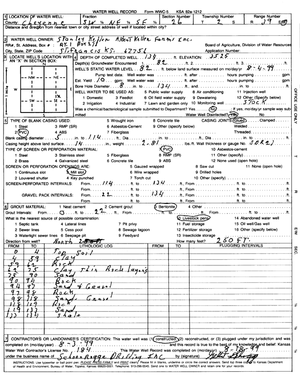
Specific Water Well Detail |
|
|
| Location Info | |||
| Owner: Albert Keller Farms | Status: Constructed | ||
| Location: T2S, R39W, Sec. 26, SW NE SE | County: Cheyenne | ||
| Directions: | |||
| Latitude: 39.8482447 | Longitude: -101.6574952 | Datum NAD 27 | |
| Latitude: 39.8482386 | Longitude: -101.6579431 | Datum NAD 83 | |
| Longitude and latitude calculated by Survey from township-range-section-quarter calls. Only good to within the quarter call accuracy. | |||
| View well on interactive map | |||
| General Info | ||
| Well Depth: 134 ft. | Elevation: 3525 ft. | |
| Static Water Level: 82 ft. | Est. Yield: 10 gpm. | |
| Comp. Date: 03-Aug-1999 | Well Use: (unstated)/abandoned | |
| DWR Applic. #: | Other ID: | |
| Links | |
| View info from Wizard Water Level Data base... | |
| No WIMAS information available. | |
| Driller Info | ||
| Driller: Schoenrogge Drilling, Inc. | License #: 184 | |
| Scanned Form | View scan |
|
Chemical Sample Submitted?: No
Water Well disinfected?: Yes | ||
| Ground water encountered: 82 ft. | ||
| Bore hole diameter: 8 inches to 134 ft | ||
| Casing Info | ||
| Casing Type: PVC
Casing Joints: Glued |
Diam: 5 in. to 114 ft | |
| Casing height above land surface: 14 in
Casing Weight: 2.81 lbs/ft Wall thickness or gauge no.: SDR21 | ||
| Screen and Perforation Info | ||
| Screen Type: PVC | Screen Openings: Mill slot | |
| Screen-perforated intervals | From: 114 ft to 134 ft | |
| Gravel pack intervals | From: 22 ft to 134 ft | |
| Grout Info | ||
| Grout used: Bentonite | From: 0 to 22 ft | |
| Source of Possible Contamination | ||
| Source: Livestock pens | ||
| Direction from well: North | Distance: 250 ft | |
| Lithologic Log
(Log data entered by KGS.) | ||
| From: 0 ft. to 4 ft. | Topsoil | |
| From: 4 ft. to 59 ft. | Clay | |
| From: 59 ft. to 62 ft. | Rock | |
| From: 62 ft. to 75 ft. | Clay thin rock layers | |
| From: 75 ft. to 90 ft. | Sand | |
| From: 90 ft. to 94 ft. | Rock | |
| From: 94 ft. to 97 ft. | Sand and gravel | |
| From: 97 ft. to 98 ft. | Rock | |
| From: 98 ft. to 118 ft. | Sand, gravel | |
| From: 118 ft. to 119 ft. | Rock | |
| From: 119 ft. to 133 ft. | Sand | |
| From: 133 ft. to 134 ft. | Shale | |