|
|
|
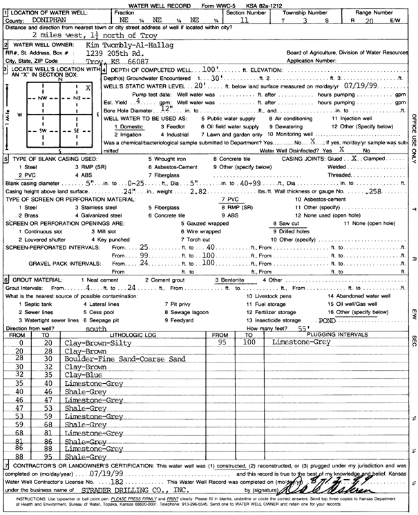
Specific Water Well Detail |
|
|
| Location Info | |||
| Owner: Twombly-Al-Halag, Kim | Status: Constructed | ||
| Location: T3S, R20E, Sec. 11, NE NE NE | County: Doniphan | ||
| Directions: From Troy, 2 miles West and 1.5 miles North | |||
| Latitude: 39.8117921 | Longitude: -95.1349154 | Datum NAD 27 | |
| Latitude: 39.8117884 | Longitude: -95.1351665 | Datum NAD 83 | |
| Longitude and latitude calculated by Survey from township-range-section-quarter calls. Only good to within the quarter call accuracy. | |||
| View well on interactive map | |||
| General Info | ||
| Well Depth: 100 ft. | Elevation: ft. | |
| Static Water Level: 20 ft. | Est. Yield: 4 gpm. | |
| Comp. Date: 19-Jul-1999 | Well Use: Domestic | |
| DWR Applic. #: | Other ID: | |
| Driller Info | ||
| Driller: Strader Drilling Co., Inc. | License #: 182 | |
| Scanned Form | View scan |
|
Chemical Sample Submitted?:
Water Well disinfected?: | ||
| Casing Info | ||
| Casing Type:
Casing Joints: |
Diam: in. to ft | |
| Casing height above land surface: in
Casing Weight: lbs/ft Wall thickness or gauge no.: | ||
| Screen and Perforation Info | ||
| Screen Type: | Screen Openings: | |
| Screen-perforated intervals | From: ft to ft | |
| Gravel pack intervals | From: ft to ft | |
| Grout Info | ||
| Grout used: | From: to ft | |
| Source of Possible Contamination | ||
| Source: | ||
| Direction from well: | Distance: ft | |
| Lithologic Log
(Log data entered by KGS.) | ||
| From: 0 ft. to 20 ft. | Silty clay, brown | |
| From: 20 ft. to 28 ft. | Clay, brown | |
| From: 28 ft. to 30 ft. | Boulders, fine sand, coarse sand | |
| From: 30 ft. to 32 ft. | Clay, brown | |
| From: 32 ft. to 35 ft. | Clay, blue | |
| From: 35 ft. to 40 ft. | Limestone, gray | |
| From: 40 ft. to 46 ft. | Shale, gray | |
| From: 46 ft. to 47 ft. | Limestone, gray | |
| From: 47 ft. to 53 ft. | Shale, gray | |
| From: 53 ft. to 59 ft. | Limestone, gray | |
| From: 59 ft. to 68 ft. | Shale, gray | |
| From: 68 ft. to 81 ft. | Limestone, gray | |
| From: 81 ft. to 86 ft. | Shale, gray | |
| From: 86 ft. to 88 ft. | Limestone, gray | |
| From: 88 ft. to 95 ft. | Shale, gray | |
| From: 95 ft. to 100 ft. | Limestone, gray | |