|
|
|
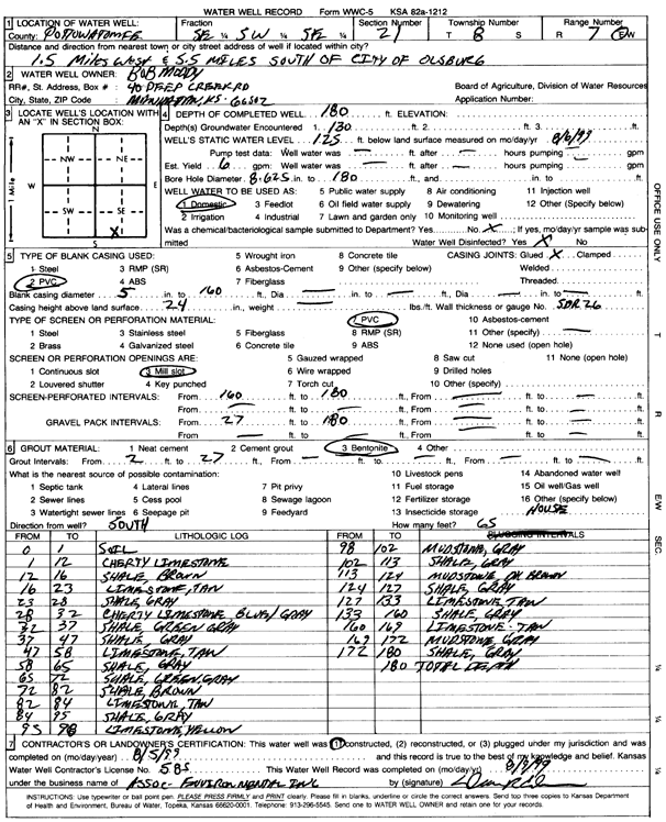
Specific Water Well Detail |
|
|
| Location Info | |||
| Owner: Moody, Bob | Status: Constructed | ||
| Location: T8S, R7E, Sec. 21, SE SW SE | County: Pottawatomie | ||
| Directions: from Olsburg: 1.5 mi W, 5.5 mi S | |||
| Latitude: 39.3353125 | Longitude: -96.6497491 | Datum NAD 27 | |
| Latitude: 39.3353092 | Longitude: -96.6500336 | Datum NAD 83 | |
| Longitude and latitude calculated by Survey from township-range-section-quarter calls. Only good to within the quarter call accuracy. | |||
| View well on interactive map | |||
| General Info | ||
| Well Depth: 180 ft. | Elevation: ft. | |
| Static Water Level: 125 ft. | Est. Yield: 6 gpm. | |
| Comp. Date: 05-Aug-1999 | Well Use: Domestic | |
| DWR Applic. #: | Other ID: | |
| Driller Info | ||
| Driller: Associated Environmental, Inc. | License #: 585 | |
| Scanned Form | View scan |
|
Chemical Sample Submitted?:
Water Well disinfected?: | ||
| Casing Info | ||
| Casing Type:
Casing Joints: |
Diam: in. to ft | |
| Casing height above land surface: in
Casing Weight: lbs/ft Wall thickness or gauge no.: | ||
| Screen and Perforation Info | ||
| Screen Type: | Screen Openings: | |
| Screen-perforated intervals | From: ft to ft | |
| Gravel pack intervals | From: ft to ft | |
| Grout Info | ||
| Grout used: | From: to ft | |
| Source of Possible Contamination | ||
| Source: | ||
| Direction from well: | Distance: ft | |
| Lithologic Log
(Log data entered by KGS.) | ||
| From: 0 ft. to 1 ft. | soil | |
| From: 1 ft. to 12 ft. | cherty limestone | |
| From: 12 ft. to 16 ft. | shale, brown | |
| From: 16 ft. to 23 ft. | limestone, tan | |
| From: 23 ft. to 28 ft. | shale, gray | |
| From: 28 ft. to 32 ft. | cherty limestone, blue-gray | |
| From: 32 ft. to 37 ft. | shale, green-gray | |
| From: 37 ft. to 47 ft. | shale, gray | |
| From: 47 ft. to 58 ft. | limestone, tan | |
| From: 58 ft. to 65 ft. | shale, gray | |
| From: 65 ft. to 72 ft. | shale, green-gray | |
| From: 72 ft. to 82 ft. | shale, brown | |
| From: 82 ft. to 84 ft. | limestone, tan | |
| From: 84 ft. to 95 ft. | shale, gray | |
| From: 95 ft. to 98 ft. | limestone, yellow | |
| From: 98 ft. to 102 ft. | mudstone, gray | |
| From: 102 ft. to 113 ft. | shale, gray | |
| From: 113 ft. to 124 ft. | mudstone, dark brown | |
| From: 124 ft. to 127 ft. | shale, gray | |
| From: 127 ft. to 133 ft. | limestone, tan | |
| From: 133 ft. to 160 ft. | shale, gray | |
| From: 160 ft. to 169 ft. | limestone, tan | |
| From: 169 ft. to 172 ft. | mudstone, gray | |
| From: 172 ft. to 180 ft. | shale, gray | |