|
|
|
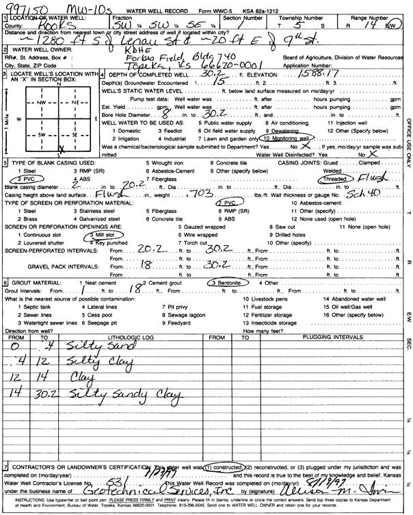
Specific Water Well Detail |
|
|
| Location Info | |||
| Owner: KDHE | Status: Constructed | ||
| Location: T5S, R14W, Sec. 1, SW SW SE | County: Smith | ||
| Directions: from Lenau St and 9th St, 1280 feet S and 20 feet E, Gaylord | |||
| Latitude: 39.6411581 | Longitude: -98.8494912 | Datum NAD 27 | |
| Latitude: 39.6411693 | Longitude: -98.8498471 | Datum NAD 83 | |
| Longitude and latitude calculated by Survey from township-range-section-quarter calls. Only good to within the quarter call accuracy. | |||
| View well on interactive map | |||
| General Info | ||
| Well Depth: 30.2 ft. | Elevation: 1588.17 ft. | |
| Static Water Level: ft. | Est. Yield: gpm. | |
| Comp. Date: 27-Jul-1999 | Well Use: Monitoring well/observation/piezometer | |
| DWR Applic. #: | Other ID: MW 10 S | |
| Driller Info | ||
| Driller: Geotechnical Services, Inc. | License #: 531 | |
| Scanned Form | View scan |
|
Chemical Sample Submitted?:
Water Well disinfected?: | ||
| Casing Info | ||
| Casing Type:
Casing Joints: |
Diam: in. to ft | |
| Casing height above land surface: in
Casing Weight: lbs/ft Wall thickness or gauge no.: | ||
| Screen and Perforation Info | ||
| Screen Type: | Screen Openings: | |
| Screen-perforated intervals | From: ft to ft | |
| Gravel pack intervals | From: ft to ft | |
| Grout Info | ||
| Grout used: | From: to ft | |
| Source of Possible Contamination | ||
| Source: | ||
| Direction from well: | Distance: ft | |
| Lithologic Log
(Log data entered by KGS.) | ||
| From: 0 ft. to 4 ft. | silty sand | |
| From: 4 ft. to 12 ft. | silty clay | |
| From: 12 ft. to 14 ft. | clay | |
| From: 14 ft. to 30.2 ft. | silty sandy clay | |