|
|
|
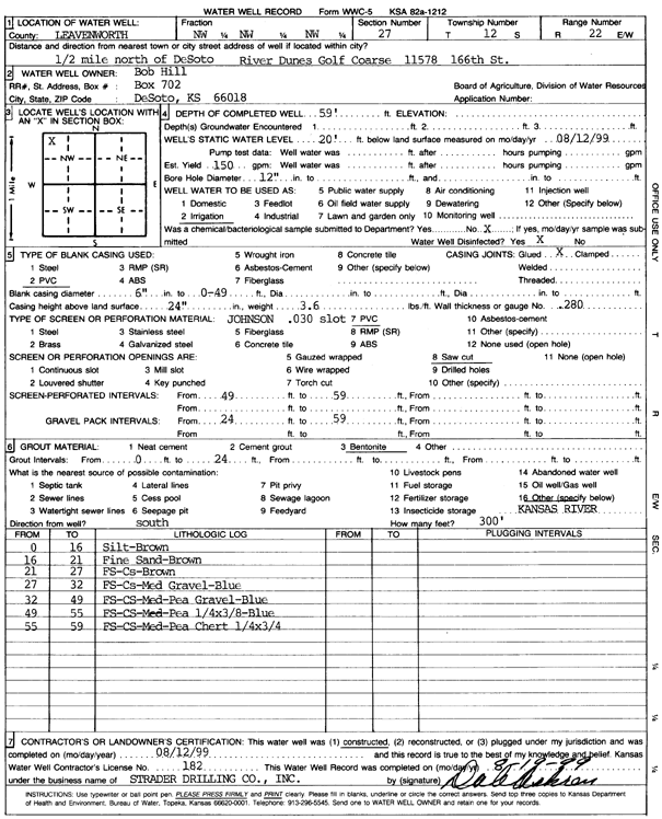
Specific Water Well Detail |
|
|
| Location Info | |||
| Owner: Hill, Bob | Status: Constructed | ||
| Location: T12S, R22E, Sec. 27, NW NW NW | County: Leavenworth | ||
| Directions: 11578 166th St, River Dunes Golf Course - from DeSoto: .5 mi N | |||
| Latitude: 38.9846468 | Longitude: -94.9633061 | Datum NAD 27 | |
| Latitude: 38.984651 | Longitude: -94.9635511 | Datum NAD 83 | |
| Longitude and latitude calculated by Survey from township-range-section-quarter calls. Only good to within the quarter call accuracy. | |||
| View well on interactive map | |||
| General Info | ||
| Well Depth: 59 ft. | Elevation: ft. | |
| Static Water Level: 20 ft. | Est. Yield: 150 gpm. | |
| Comp. Date: 12-Aug-1999 | Well Use: Irrigation | |
| DWR Applic. #: | Other ID: | |
| Links | |
| No Wizard information available. | |
| View info from WIMAS Water Right Data base... | |
| Driller Info | ||
| Driller: Strader Drilling Co., Inc. | License #: 182 | |
| Scanned Form | View scan |
|
Chemical Sample Submitted?:
Water Well disinfected?: | ||
| Casing Info | ||
| Casing Type:
Casing Joints: |
Diam: in. to ft | |
| Casing height above land surface: in
Casing Weight: lbs/ft Wall thickness or gauge no.: | ||
| Screen and Perforation Info | ||
| Screen Type: | Screen Openings: | |
| Screen-perforated intervals | From: ft to ft | |
| Gravel pack intervals | From: ft to ft | |
| Grout Info | ||
| Grout used: | From: to ft | |
| Source of Possible Contamination | ||
| Source: | ||
| Direction from well: | Distance: ft | |
| Lithologic Log
(Log data entered by KGS.) | ||
| From: 0 ft. to 16 ft. | silt, brown | |
| From: 16 ft. to 21 ft. | fine sand brown | |
| From: 21 ft. to 27 ft. | fine sand, coarse sand, brown | |
| From: 27 ft. to 32 ft. | fine sand, coarse sand, medium gravel, blue | |
| From: 32 ft. to 49 ft. | fine sand, coarse sand, medium pea gravel, blue | |
| From: 49 ft. to 55 ft. | fine sand, coarse sand, medium pea (1/4 by 3/8 inch), blue | |
| From: 55 ft. to 59 ft. | fine sand, coarse sand, pea chert (1/4 by 3/4 inch) | |