|
|
|
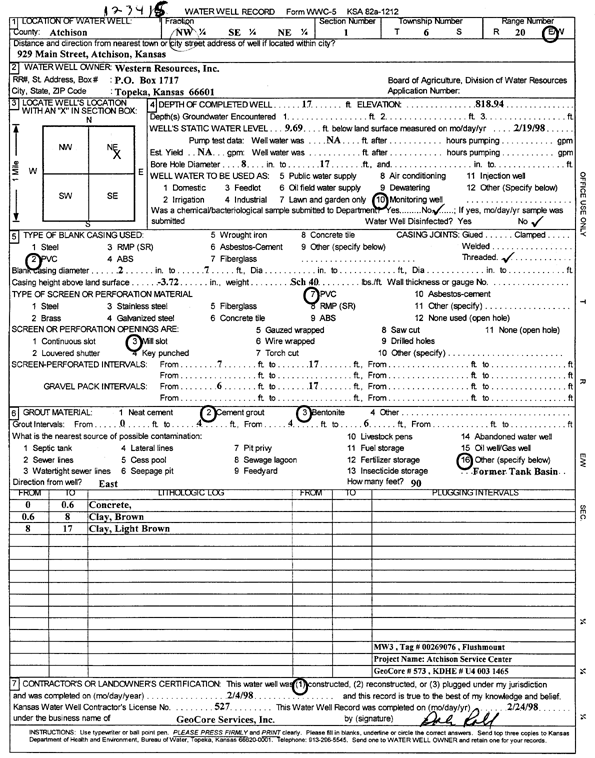
Specific Water Well Detail |
|
|
| Location Info | |||
| Owner: Western Resources, Inc. | Status: Constructed | ||
| Location: T6S, R20E, Sec. 1, NW SE NE | County: Atchison | ||
| Directions: 929 Main St, Atchison | |||
| Latitude: 39.5605493 | Longitude: -95.1269792 | Datum NAD 27 | |
| Latitude: 39.5605458 | Longitude: -95.127226 | Datum NAD 83 | |
| Longitude and latitude calculated by Survey from township-range-section-quarter calls. Only good to within the quarter call accuracy. | |||
| View well on interactive map | |||
| General Info | ||
| Well Depth: 17 ft. | Elevation: 818.94 ft. | |
| Static Water Level: 9.69 ft. | Est. Yield: gpm. | |
| Comp. Date: 04-Feb-1998 | Well Use: Monitoring well/observation/piezometer | |
| DWR Applic. #: | Other ID: MW 3 | |
| Driller Info | ||
| Driller: GeoCore Services Inc. | License #: 527 | |
| Scanned Form | View scan |
|
Chemical Sample Submitted?:
Water Well disinfected?: | ||
| Casing Info | ||
| Casing Type:
Casing Joints: |
Diam: in. to ft | |
| Casing height above land surface: in
Casing Weight: lbs/ft Wall thickness or gauge no.: | ||
| Screen and Perforation Info | ||
| Screen Type: | Screen Openings: | |
| Screen-perforated intervals | From: ft to ft | |
| Gravel pack intervals | From: ft to ft | |
| Grout Info | ||
| Grout used: | From: to ft | |
| Source of Possible Contamination | ||
| Source: | ||
| Direction from well: | Distance: ft | |
| Lithologic Log
(Log data entered by KGS.) | ||
| From: 0 ft. to .6 ft. | Concrete | |
| From: .6 ft. to 8 ft. | Clay, brown | |
| From: 8 ft. to 17 ft. | Clay, light brown | |