|
|
|
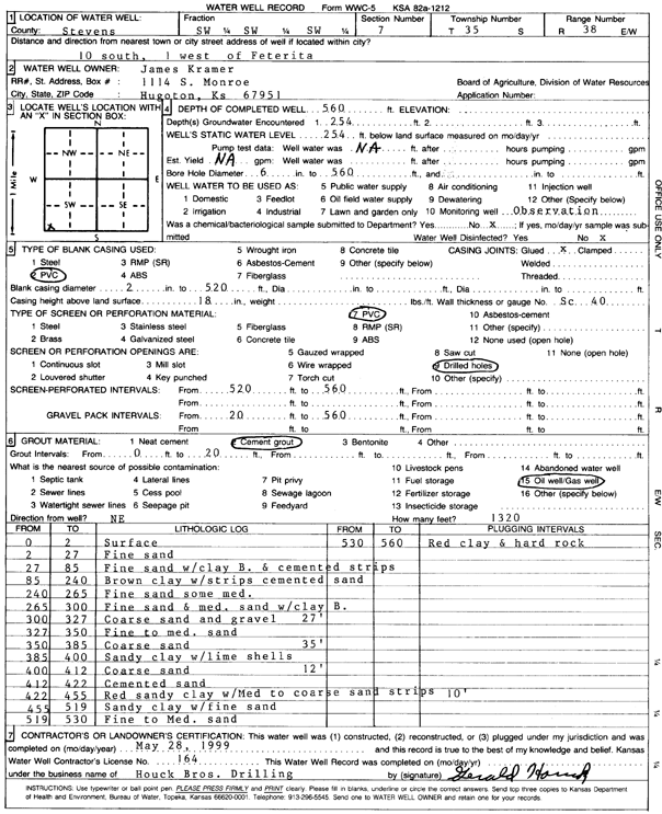
Specific Water Well Detail |
|
|
| Location Info | |||
| Owner: Kramer, James | Status: Constructed | ||
| Location: T35S, R38W, Sec. 7, SW SW SW | County: Stevens | ||
| Directions: from Feterita, 10 mi S and 1 mi W | |||
| Latitude: 37.0111765 | Longitude: -101.4996175 | Datum NAD 27 | |
| Latitude: 37.0112039 | Longitude: -101.5000554 | Datum NAD 83 | |
| Longitude and latitude calculated by Survey from township-range-section-quarter calls. Only good to within the quarter call accuracy. | |||
| View well on interactive map | |||
| General Info | ||
| Well Depth: 560 ft. | Elevation: ft. | |
| Static Water Level: 254 ft. | Est. Yield: gpm. | |
| Comp. Date: 28-May-1999 | Well Use: Monitoring well/observation/piezometer | |
| DWR Applic. #: | Other ID: | |
| Links | |
| View info from Wizard Water Level Data base... | |
| No WIMAS information available. | |
| Driller Info | ||
| Driller: Gerald Houck Bros. Drilling Co. | License #: 164 | |
| Scanned Form | View scan |
|
Chemical Sample Submitted?:
Water Well disinfected?: | ||
| Casing Info | ||
| Casing Type: PVC
Casing Joints: |
Diam: 2 in. to 520 ft | |
| Casing height above land surface: in
Casing Weight: lbs/ft Wall thickness or gauge no.: | ||
| Screen and Perforation Info | ||
| Screen Type: PVC | Screen Openings: | |
| Screen-perforated intervals | From: 520 ft to 560 ft | |
| Gravel pack intervals | From: ft to ft | |
| Grout Info | ||
| Grout used: | From: to ft | |
| Source of Possible Contamination | ||
| Source: | ||
| Direction from well: | Distance: ft | |
| Lithologic Log
(Log data entered by KGS.) | ||
| From: 0 ft. to 2 ft. | surface | |
| From: 2 ft. to 27 ft. | fine sand | |
| From: 27 ft. to 85 ft. | fine sand with clay b. and cemented strips | |
| From: 85 ft. to 240 ft. | brown clay with strips cemented sand | |
| From: 240 ft. to 265 ft. | fine sand some med. | |
| From: 265 ft. to 300 ft. | fine sand and medium sand with clay B. | |
| From: 300 ft. to 327 ft. | coarse sand and gravel | |
| From: 327 ft. to 350 ft. | fine to medium sand | |
| From: 350 ft. to 385 ft. | coarse sand | |
| From: 385 ft. to 400 ft. | sandy clay with lime shells | |
| From: 400 ft. to 412 ft. | coarse sand | |
| From: 412 ft. to 422 ft. | cemented sand | |
| From: 422 ft. to 455 ft. | red sandy clay with med to coarse sand strips | |
| From: 455 ft. to 519 ft. | sandy clay with fine sand | |
| From: 519 ft. to 530 ft. | fine to medium sand | |
| From: 530 ft. to 560 ft. | red clay and hard rock | |