|
|
|
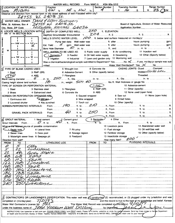
Specific Water Well Detail |
|
|
| Location Info | |||
| Owner: Swanson, David and Ellen | Status: Constructed | ||
| Location: T16S, R23E, Sec. 4, NW SE NW | County: Miami | ||
| Directions: 24755 W 240th St, Hillsdale | |||
| Latitude: 38.690139 | Longitude: -94.8768613 | Datum NAD 27 | |
| Latitude: 38.6901492 | Longitude: -94.8771017 | Datum NAD 83 | |
| Longitude and latitude calculated by Survey from township-range-section-quarter calls. Only good to within the quarter call accuracy. | |||
| View well on interactive map | |||
| General Info | ||
| Well Depth: 250 ft. | Elevation: ft. | |
| Static Water Level: 100 ft. | Est. Yield: 5 gpm. | |
| Comp. Date: 21-Jul-1999 | Well Use: Domestic | |
| DWR Applic. #: | Other ID: | |
| Driller Info | ||
| Driller: Jesse Yoakum Well Drilling | License #: 595 | |
| Scanned Form | View scan |
|
Chemical Sample Submitted?:
Water Well disinfected?: | ||
| Casing Info | ||
| Casing Type:
Casing Joints: |
Diam: in. to ft | |
| Casing height above land surface: in
Casing Weight: lbs/ft Wall thickness or gauge no.: | ||
| Screen and Perforation Info | ||
| Screen Type: | Screen Openings: | |
| Screen-perforated intervals | From: ft to ft | |
| Gravel pack intervals | From: ft to ft | |
| Grout Info | ||
| Grout used: | From: to ft | |
| Source of Possible Contamination | ||
| Source: | ||
| Direction from well: | Distance: ft | |
| Lithologic Log
(Log data entered by KGS.) | ||
| From: 0 ft. to 5 ft. | Clay | |
| From: 5 ft. to 22 ft. | Limestone | |
| From: 22 ft. to 48 ft. | Shale, gray | |
| From: 48 ft. to 68 ft. | Sand | |
| From: 68 ft. to 122 ft. | Shale | |
| From: 122 ft. to 168 ft. | Limestone | |
| From: 168 ft. to 180 ft. | Shale | |
| From: 180 ft. to 186 ft. | Limestone | |
| From: 186 ft. to 188 ft. | Shale | |
| From: 188 ft. to 216 ft. | Limestone | |
| From: 216 ft. to 240 ft. | Shale | |
| From: 240 ft. to 250 ft. | Limestone | |