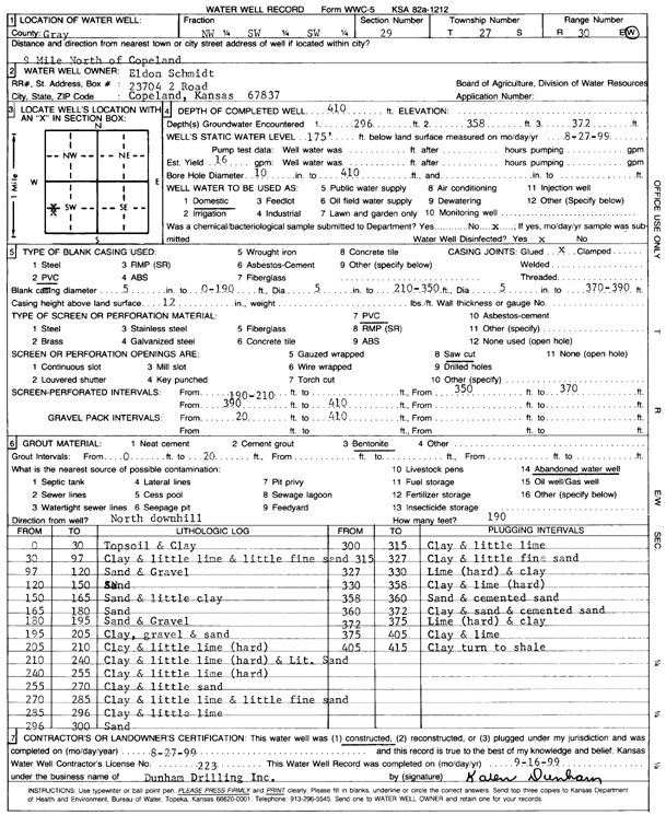
Lithologic Log
(Log data entered by KGS.) |
| |
From: 0 ft. to 30 ft. |
Topsoil and Clay |
| |
From: 30 ft. to 97 ft. |
Clay and little lime and little fine sand |
| |
From: 97 ft. to 120 ft. |
Sand and Gravel |
| |
From: 120 ft. to 150 ft. |
Sand |
| |
From: 150 ft. to 165 ft. |
Sand and little clay |
| |
From: 165 ft. to 180 ft. |
Sand |
| |
From: 180 ft. to 195 ft. |
Sand and Gravel |
| |
From: 195 ft. to 205 ft. |
Clay, gravel and sand |
| |
From: 205 ft. to 210 ft. |
Clay and little lime (hard) |
| |
From: 210 ft. to 240 ft. |
Clay and little lime (hard) and Lit. Sand |
| |
From: 240 ft. to 255 ft. |
Clay and little lime (hard) |
| |
From: 255 ft. to 270 ft. |
Clay and little sand |
| |
From: 270 ft. to 285 ft. |
Clay and little lime and little fine sand |
| |
From: 285 ft. to 296 ft. |
Clay and little lime |
| |
From: 296 ft. to 300 ft. |
Sand |
| |
From: 300 ft. to 315 ft. |
Clay and little lime |
| |
From: 315 ft. to 327 ft. |
Clay and little fine sand |
| |
From: 327 ft. to 330 ft. |
Lime (hard) and clay |
| |
From: 330 ft. to 358 ft. |
Clay and lime (hard) |
| |
From: 358 ft. to 360 ft. |
Sand and cemented sand |
| |
From: 360 ft. to 372 ft. |
Clay and sand and cemented sand |
| |
From: 372 ft. to 375 ft. |
Lime (hard) and clay |
| |
From: 375 ft. to 405 ft. |
Clay and lime |
| |
From: 405 ft. to 415 ft. |
Clay turn to shale |