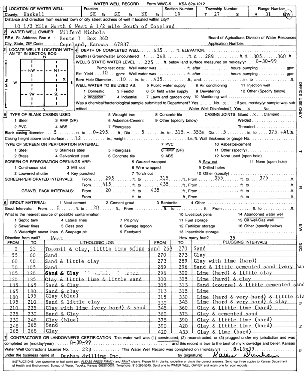
Lithologic Log
(Log data entered by KGS.) |
| |
From: 0 ft. to 55 ft. |
topsoil and clay, little lime and fine sand |
| |
From: 55 ft. to 60 ft. |
sand |
| |
From: 60 ft. to 90 ft. |
sand and little clay |
| |
From: 90 ft. to 105 ft. |
sand |
| |
From: 105 ft. to 120 ft. |
sand and clay |
| |
From: 120 ft. to 135 ft. |
clay and little lime and little sand |
| |
From: 135 ft. to 165 ft. |
sand and clay |
| |
From: 165 ft. to 180 ft. |
sand and clay |
| |
From: 180 ft. to 195 ft. |
clay (blue) |
| |
From: 195 ft. to 210 ft. |
sand and little clay |
| |
From: 210 ft. to 225 ft. |
clay with lime (very hard) and sand |
| |
From: 225 ft. to 230 ft. |
sand and clay |
| |
From: 230 ft. to 248 ft. |
clay (blue) |
| |
From: 248 ft. to 265 ft. |
sand |
| |
From: 265 ft. to 268 ft. |
clay |
| |
From: 268 ft. to 270 ft. |
sand |
| |
From: 270 ft. to 273 ft. |
clay |
| |
From: 273 ft. to 289 ft. |
clay with lime (hard) |
| |
From: 289 ft. to 296 ft. |
sand and little cemented sand (very hard) |
| |
From: 296 ft. to 300 ft. |
lime (hard) and little clay |
| |
From: 300 ft. to 305 ft. |
lime (hard) and clay |
| |
From: 305 ft. to 313 ft. |
coarse sand and little cemented sand |
| |
From: 313 ft. to 315 ft. |
lime |
| |
From: 315 ft. to 330 ft. |
lime (hard and very hard) and little clay |
| |
From: 330 ft. to 345 ft. |
lime (hard and very hard) and clay |
| |
From: 345 ft. to 360 ft. |
clay and little lime (hard) |
| |
From: 360 ft. to 375 ft. |
clay and cemented sand |
| |
From: 375 ft. to 390 ft. |
clay and little lime (hard) |
| |
From: 390 ft. to 420 ft. |
clay and little lime (hard) |
| |
From: 420 ft. to 435 ft. |
clay and lime (hard) |