|
|
|
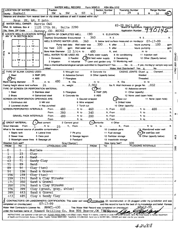
Specific Water Well Detail |
|
|
| Location Info | |||
| Owner: Harris Oil and Gas | Status: Constructed | ||
| Location: T29S, R34W, Sec. 29, NW SW SE | County: Haskell | ||
| Directions: from Ryus, 2 mi E, 0.25 mi N, and E into site | |||
| Latitude: 37.4922526 | Longitude: -101.0608178 | Datum NAD 27 | |
| Latitude: 37.4922771 | Longitude: -101.0612639 | Datum NAD 83 | |
| Longitude and latitude calculated by Survey from township-range-section-quarter calls. Only good to within the quarter call accuracy. | |||
| View well on interactive map | |||
| General Info | ||
| Well Depth: 480 ft. | Elevation: ft. | |
| Static Water Level: 360 ft. | Est. Yield: gpm. | |
| Comp. Date: 17-Jul-1999 | Well Use: Oil Field Water Supply | |
| DWR Applic. #: 990145 | Other ID: Hall MLP 2-29 | |
| Links | |
| No Wizard information available. | |
| View info from WIMAS Water Right Data base... | |
| Driller Info | ||
| Driller: Howard Drilling Company AG, LLC | License #: 430 | |
| Scanned Form | View scan |
|
Chemical Sample Submitted?:
Water Well disinfected?: | ||
| Casing Info | ||
| Casing Type:
Casing Joints: |
Diam: in. to ft | |
| Casing height above land surface: in
Casing Weight: lbs/ft Wall thickness or gauge no.: | ||
| Screen and Perforation Info | ||
| Screen Type: | Screen Openings: | |
| Screen-perforated intervals | From: ft to ft | |
| Gravel pack intervals | From: ft to ft | |
| Grout Info | ||
| Grout used: | From: to ft | |
| Source of Possible Contamination | ||
| Source: | ||
| Direction from well: | Distance: ft | |
| Lithologic Log
(Log data entered by KGS.) | ||
| From: 0 ft. to 1 ft. | surface | |
| From: 1 ft. to 23 ft. | clay | |
| From: 23 ft. to 43 ft. | sand | |
| From: 43 ft. to 71 ft. | sandy clay | |
| From: 71 ft. to 89 ft. | sand | |
| From: 89 ft. to 94 ft. | clay (tan) | |
| From: 94 ft. to 156 ft. | sand and gravel | |
| From: 156 ft. to 159 ft. | clay (tan) | |
| From: 159 ft. to 174 ft. | sand and clay streaks | |
| From: 174 ft. to 350 ft. | sand and gravel | |
| From: 350 ft. to 376 ft. | sand and clay streaks | |
| From: 376 ft. to 399 ft. | clay (green, gray, and blue) | |
| From: 399 ft. to 443 ft. | sand and gravel | |
| From: 443 ft. to 485 ft. | clay and sandy clay | |