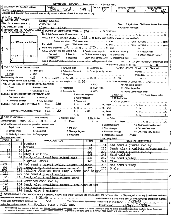
KGS Home Page Water Well Data base Specific Water Well Detail
Water Resources

Well T8S, R38W, Sec. 19, SW SW SW, Action: Constructed

Location Info
Owner: Dautel, Kenny Status: Constructed
Location: T8S, R38W, Sec. 19, SW SW SW County: Sherman
Directions: From Goodland, 4 miles East
Latitude: 39.3378492 Longitude: -101.6125425 Datum NAD 27
Latitude: 39.3378501 Longitude: -101.6129897 Datum NAD 83
Longitude and latitude calculated by Survey from township-range-section-quarter calls. Only good to within the quarter call accuracy.
View well on interactive map
General Info
Well Depth: 276 ft. Elevation: ft.
Static Water Level: 165 ft. Est. Yield: gpm.
Comp. Date: 21-Jun-1999 Well Use: Domestic
DWR Applic. #: Other ID:
Driller Info
Driller: Woofter Pump & Well, Inc. License #: 554
Scanned Form
View form(s) on screen Download scan(s)
The download files contain one or more TIFF images compressed into a ZIP archive. Your browser may be already set up to decompress these files. The TIFFs are 300 dpi archival-quality scans of the WWC5 forms and can be viewed by software like Adobe PhotoShop.
Chemical Sample Submitted?:
Water Well disinfected?:
Casing Info
Casing Type:
Casing Joints:
Diam: in. to ft
Casing height above land surface: in
Casing Weight: lbs/ft
Wall thickness or gauge no.:
Screen and Perforation Info
Screen Type: Screen Openings:
Screen-perforated intervals From: ft to ft
Gravel pack intervals From: ft to ft
Grout Info
Grout used: From: to ft
Source of Possible Contamination
Source:
Direction from well: Distance: ft
Lithologic Log
(Log data entered by KGS.)
From: 0 ft. to 2 ft. Surface
From: 2 ft. to 19 ft. Loess
From: 19 ft. to 36 ft. Clay
From: 36 ft. to 52 ft. Clay and caliche
From: 52 ft. to 69 ft. Sandy clay, caliche with medium sand and gravel streaks
From: 69 ft. to 94 ft. medium sand and gravel with clay layers, loose
From: 94 ft. to 109 ft. Sandy clay and caliche with some sand
From: 109 ft. to 118 ft. Caliche, cemented sand, clay, and some sand, tight
From: 118 ft. to 126 ft. Medium sand and gravel with clay
From: 126 ft. to 141 ft. Sandy clay and caliche with some sand
From: 141 ft. to 145 ft. Cemented sand with clay
From: 145 ft. to 154 ft. Sandy clay with caliche streaks and few sand streaks
From: 154 ft. to 167 ft. Medium sand and gravel
From: 167 ft. to 174 ft. Sandy clay and caliche
From: 174 ft. to 181 ft. Medium sand and gravel with clay
From: 181 ft. to 223 ft. Sandy clay and caliche with some sand
From: 223 ft. to 239 ft. Medium sand and gravel with clay
From: 239 ft. to 241 ft. Hard caliche
From: 241 ft. to 247 ft. Medium sand with clay
From: 247 ft. to 248 ft. Clay
From: 248 ft. to 273 ft. Medium sand with clay
From: 273 ft. to 276 ft. Shale

Kansas Geological Survey
Comments to webadmin@kgs.ku.edu
URL=http://www.kgs.ku.edu/Magellan/WaterWell/index.html
Display Programs Updated July 2, 2014
Data added continuously.