|
|
|
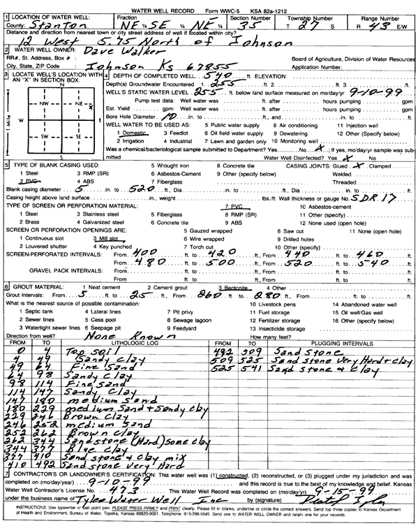
Specific Water Well Detail |
|
|
| Location Info | |||
| Owner: Walker, Dave | Status: Constructed | ||
| Location: T27S, R43W, Sec. 35, NE SE NE | County: Stanton | ||
| Directions: from Johnson, 12 mi W and 5.75 mi N | |||
| Latitude: 37.661217 | Longitude: -101.9802389 | Datum NAD 27 | |
| Latitude: 37.6612308 | Longitude: -101.9806946 | Datum NAD 83 | |
| Longitude and latitude calculated by Survey from township-range-section-quarter calls. Only good to within the quarter call accuracy. | |||
| View well on interactive map | |||
| General Info | ||
| Well Depth: 540 ft. | Elevation: ft. | |
| Static Water Level: 255 ft. | Est. Yield: gpm. | |
| Comp. Date: 10-Sep-1999 | Well Use: Domestic | |
| DWR Applic. #: | Other ID: | |
| Driller Info | ||
| Driller: Tyler Water Well, Inc. | License #: 473 | |
| Scanned Form | View scan |
|
Chemical Sample Submitted?:
Water Well disinfected?: | ||
| Casing Info | ||
| Casing Type:
Casing Joints: |
Diam: in. to ft | |
| Casing height above land surface: in
Casing Weight: lbs/ft Wall thickness or gauge no.: | ||
| Screen and Perforation Info | ||
| Screen Type: | Screen Openings: | |
| Screen-perforated intervals | From: ft to ft | |
| Gravel pack intervals | From: ft to ft | |
| Grout Info | ||
| Grout used: | From: to ft | |
| Source of Possible Contamination | ||
| Source: | ||
| Direction from well: | Distance: ft | |
| Lithologic Log
(Log data entered by KGS.) | ||
| From: 0 ft. to 4 ft. | top soil | |
| From: 4 ft. to 49 ft. | sandy clay | |
| From: 49 ft. to 64 ft. | fine sand | |
| From: 64 ft. to 98 ft. | sandy clay | |
| From: 98 ft. to 114 ft. | fine sand | |
| From: 114 ft. to 147 ft. | sandy clay | |
| From: 147 ft. to 180 ft. | medium sand | |
| From: 180 ft. to 229 ft. | medium sand and sandy clay | |
| From: 229 ft. to 246 ft. | brown clay | |
| From: 246 ft. to 252 ft. | medium sand | |
| From: 252 ft. to 262 ft. | brown clay | |
| From: 262 ft. to 344 ft. | sandstone (hard) some clay | |
| From: 344 ft. to 377 ft. | blue clay | |
| From: 377 ft. to 410 ft. | sandstone and clay mix | |
| From: 410 ft. to 492 ft. | sandstone very hard | |
| From: 492 ft. to 509 ft. | sandstone | |
| From: 509 ft. to 525 ft. | sandstone very hard and clay | |
| From: 525 ft. to 541 ft. | sandstone and clay | |