|
|
|
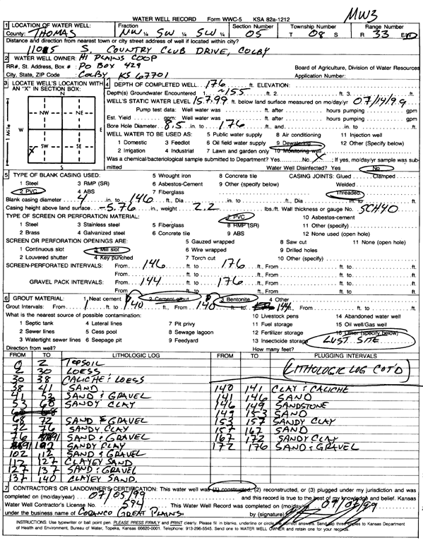
Specific Water Well Detail |
|
|
| Location Info | |||
| Owner: Hi Plains Coop | Status: Constructed | ||
| Location: T8S, R33W, Sec. 5, NW SW SW | County: Thomas | ||
| Directions: 1105 S Country Club Dr, Colby | |||
| Latitude: 39.3825325 | Longitude: -101.0349483 | Datum NAD 27 | |
| Latitude: 39.3825364 | Longitude: -101.0353809 | Datum NAD 83 | |
| Longitude and latitude calculated by Survey from township-range-section-quarter calls. Only good to within the quarter call accuracy. | |||
| View well on interactive map | |||
| General Info | ||
| Well Depth: 176 ft. | Elevation: ft. | |
| Static Water Level: 157.99 ft. | Est. Yield: gpm. | |
| Comp. Date: 05-Jul-1999 | Well Use: Monitoring well/observation/piezometer | |
| DWR Applic. #: | Other ID: MW 3 | |
| Driller Info | ||
| Driller: Coranco Great Plains, Inc. | License #: 594 | |
| Scanned Form | View scan |
|
Chemical Sample Submitted?:
Water Well disinfected?: | ||
| Casing Info | ||
| Casing Type:
Casing Joints: |
Diam: in. to ft | |
| Casing height above land surface: in
Casing Weight: lbs/ft Wall thickness or gauge no.: | ||
| Screen and Perforation Info | ||
| Screen Type: | Screen Openings: | |
| Screen-perforated intervals | From: ft to ft | |
| Gravel pack intervals | From: ft to ft | |
| Grout Info | ||
| Grout used: | From: to ft | |
| Source of Possible Contamination | ||
| Source: | ||
| Direction from well: | Distance: ft | |
| Lithologic Log
(Log data entered by KGS.) | ||
| From: 0 ft. to 2 ft. | top soil | |
| From: 2 ft. to 30 ft. | loess | |
| From: 30 ft. to 38 ft. | caliche and loess | |
| From: 38 ft. to 41 ft. | sand | |
| From: 41 ft. to 53 ft. | sand and gravel | |
| From: 53 ft. to 68 ft. | sandy clay | |
| From: 68 ft. to 72 ft. | sand and gravel | |
| From: 72 ft. to 76 ft. | sandy clay | |
| From: 76 ft. to 91 ft. | sand and gravel | |
| From: 91 ft. to 102 ft. | sandy clay | |
| From: 102 ft. to 112 ft. | sand and gravel | |
| From: 112 ft. to 127 ft. | clayey sand | |
| From: 127 ft. to 137 ft. | sand and gravel | |
| From: 137 ft. to 140 ft. | clayey sand | |
| From: 140 ft. to 141 ft. | clay and caliche | |
| From: 141 ft. to 146 ft. | sand | |
| From: 146 ft. to 149 ft. | sandstone | |
| From: 149 ft. to 153 ft. | sand | |
| From: 153 ft. to 157 ft. | sandy clay | |
| From: 157 ft. to 167 ft. | sand | |
| From: 167 ft. to 172 ft. | sandy clay | |
| From: 172 ft. to 176 ft. | sand and gravel | |