|
|
|
Specific Water Well Detail |
|
|
| Location Info | |||
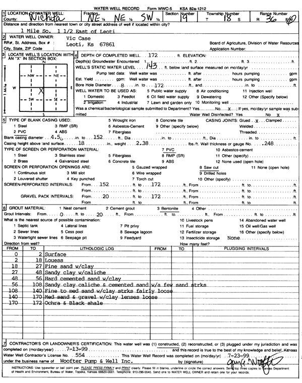
| Owner: Case, Vic | Status: Constructed | ||
| Location: T18S, R36W, Sec. 19, NE NE SW | County: Wichita | ||
| Directions: from Leoti, 1 mi S, 1.5 mi E | |||
| Latitude: 38.4732991 | Longitude: -101.3407494 | Datum NAD 27 | |
| Latitude: 38.4733182 | Longitude: -101.341187 | Datum NAD 83 | |
| Longitude and latitude calculated by Survey from township-range-section-quarter calls. Only good to within the quarter call accuracy. | |||
| View well on interactive map | |||
| General Info | ||
| Well Depth: 172 ft. | Elevation: ft. | |
| Static Water Level: 143 ft. | Est. Yield: gpm. | |
| Comp. Date: 13-Jul-1999 | Well Use: Domestic | |
| DWR Applic. #: | Other ID: | |
| Driller Info | ||
| Driller: Woofter Pump & Well, Inc. | License #: 554 | |
| Scanned Form | View scan |
|
Chemical Sample Submitted?:
Water Well disinfected?: | ||
| Casing Info | ||
| Casing Type:
Casing Joints: |
Diam: in. to ft | |
| Casing height above land surface: in
Casing Weight: lbs/ft Wall thickness or gauge no.: | ||
| Screen and Perforation Info | ||
| Screen Type: | Screen Openings: | |
| Screen-perforated intervals | From: ft to ft | |
| Gravel pack intervals | From: ft to ft | |
| Grout Info | ||
| Grout used: | From: to ft | |
| Source of Possible Contamination | ||
| Source: | ||
| Direction from well: | Distance: ft | |
| Lithologic Log
(Log data entered by KGS.) | ||
| From: 0 ft. to 2 ft. | Surface | |
| From: 2 ft. to 18 ft. | Loess | |
| From: 18 ft. to 27 ft. | Fine sand with clay | |
| From: 27 ft. to 48 ft. | Sandy clay with caliche | |
| From: 48 ft. to 56 ft. | Hard cemented sand with clay | |
| From: 56 ft. to 108 ft. | Sandy clay, caliche, and cemented sand with a few sand streaks | |
| From: 108 ft. to 140 ft. | Fine to medium sand with clay streaks, fairly loose | |
| From: 140 ft. to 170 ft. | Medium sand and gravel with clay lenses, loose | |
| From: 170 ft. to 172 ft. | Ochre and black shale | |