|
|
|
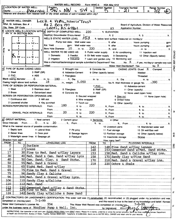
Specific Water Well Detail |
|
|
| Location Info | |||
| Owner: Lee H. and Vera Roberts Trust | Status: Constructed | ||
| Location: T21S, R38W, Sec. 5, SW NW SW | County: Kearny | ||
| Directions: | |||
| Latitude: 38.2533567 | Longitude: -101.5229581 | Datum NAD 27 | |
| Latitude: 38.2533742 | Longitude: -101.5234025 | Datum NAD 83 | |
| Longitude and latitude calculated by Survey from township-range-section-quarter calls. Only good to within the quarter call accuracy. | |||
| View well on interactive map | |||
| General Info | ||
| Well Depth: 220 ft. | Elevation: ft. | |
| Static Water Level: 153 ft. | Est. Yield: gpm. | |
| Comp. Date: 01-Jul-1999 | Well Use: Domestic, Livestock | |
| DWR Applic. #: | Other ID: | |
| Driller Info | ||
| Driller: Woofter Pump & Well, Inc. | License #: 554 | |
| Scanned Form | View scan |
|
Chemical Sample Submitted?:
Water Well disinfected?: | ||
| Casing Info | ||
| Casing Type:
Casing Joints: |
Diam: in. to ft | |
| Casing height above land surface: in
Casing Weight: lbs/ft Wall thickness or gauge no.: | ||
| Screen and Perforation Info | ||
| Screen Type: | Screen Openings: | |
| Screen-perforated intervals | From: ft to ft | |
| Gravel pack intervals | From: ft to ft | |
| Grout Info | ||
| Grout used: | From: to ft | |
| Source of Possible Contamination | ||
| Source: | ||
| Direction from well: | Distance: ft | |
| Lithologic Log
(Log data entered by KGS.) | ||
| From: 0 ft. to 2 ft. | surface | |
| From: 2 ft. to 17 ft. | loess | |
| From: 17 ft. to 30 ft. | fine to medium sand with clay layers | |
| From: 30 ft. to 40 ft. | medium sand and cemented sand with clay layers | |
| From: 40 ft. to 50 ft. | cemented sand, clay, and sand streaks | |
| From: 50 ft. to 55 ft. | medium sand and gravel | |
| From: 55 ft. to 65 ft. | tight medium sand with clay | |
| From: 65 ft. to 75 ft. | fine to medium sand and gravel | |
| From: 75 ft. to 96 ft. | sandy clay and caliche | |
| From: 96 ft. to 106 ft. | medium sand and gravel with clay layers | |
| From: 106 ft. to 110 ft. | sandy clay with caliche | |
| From: 110 ft. to 112 ft. | medium sand | |
| From: 112 ft. to 120 ft. | cemented sand with clay and sand streaks | |
| From: 120 ft. to 124 ft. | fine to medium sand | |
| From: 124 ft. to 142 ft. | sandy clay with caliche and some sand | |
| From: 142 ft. to 148 ft. | fine sand with clay lenses | |
| From: 148 ft. to 153 ft. | cemented sand with medium sand streaks | |
| From: 153 ft. to 158 ft. | medium sand and caliche with clay lens | |
| From: 158 ft. to 170 ft. | sandy clay with fine sand | |
| From: 170 ft. to 218 ft. | medium sand and gravel with clay lens | |
| From: 218 ft. to 220 ft. | ochre and shale | |