|
|
|
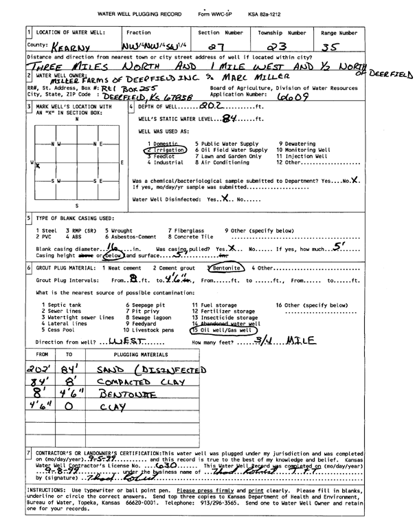
Specific Water Well Detail |
|
|
| Location Info | |||
| Owner: Miller Farms of Deerfield, Inc. | Status: Plugged | ||
| Location: T23S, R35W, Sec. 27, NW NW SW | County: Kearny | ||
| Directions: from Deerfield: 3 mi N, 1 mi W, .5 mi N | |||
| Latitude: 38.023805 | Longitude: -101.1561477 | Datum NAD 27 | |
| Latitude: 38.0238266 | Longitude: -101.1565931 | Datum NAD 83 | |
| Longitude and latitude calculated by Survey from township-range-section-quarter calls. Only good to within the quarter call accuracy. | |||
| View well on interactive map | |||
| General Info | ||
| Well Depth: 202 ft. | Elevation: ft. | |
| Static Water Level: 84 ft. | Est. Yield: gpm. | |
| Comp. Date: 05-Sep-1999 | Well Use: Irrigation | |
| DWR Applic. #: 6609 | Other ID: | |
| Links | |
| View info from Wizard Water Level Data base... | |
| View info from WIMAS Water Right Data base... | |
| Driller Info | ||
| Driller: Thad Robert T & T | License #: 630 | |
| Scanned Form | View scan |
| Casing Info | ||
|
Casing Type:
Diam: in. Casing height above land surface: in | ||
| Grout Info | ||
| Grout used: | From: to ft | |
| Source of Possible Contamination | ||
| Source: | ||
| Direction from well: | Distance: ft | |