|
|
|
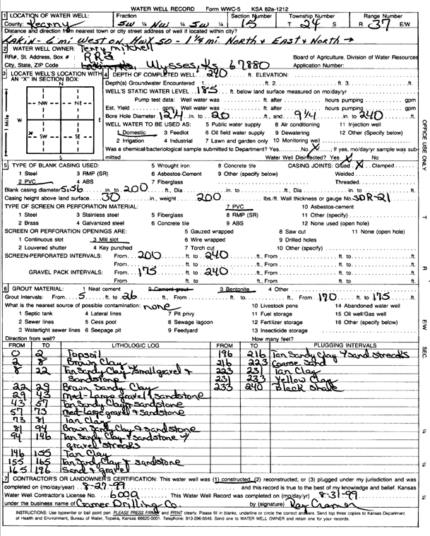
Specific Water Well Detail |
|
|
| Location Info | |||
| Owner: Mitchel, Terry | Status: Constructed | ||
| Location: T24S, R37W, Sec. 15, SW NW SW | County: Kearny | ||
| Directions: from Lakin: 6 mi W on hwy 50, 1.25 mi NE, N into site | |||
| Latitude: 37.9633927 | Longitude: -101.3756056 | Datum NAD 27 | |
| Latitude: 37.9634104 | Longitude: -101.3760532 | Datum NAD 83 | |
| Longitude and latitude calculated by Survey from township-range-section-quarter calls. Only good to within the quarter call accuracy. | |||
| View well on interactive map | |||
| General Info | ||
| Well Depth: 240 ft. | Elevation: ft. | |
| Static Water Level: 185 ft. | Est. Yield: gpm. | |
| Comp. Date: 27-Aug-1999 | Well Use: Domestic | |
| DWR Applic. #: | Other ID: | |
| Driller Info | ||
| Driller: Ray Cramer Drilling Co. | License #: 600 | |
| Scanned Form | View scan |
|
Chemical Sample Submitted?:
Water Well disinfected?: | ||
| Casing Info | ||
| Casing Type:
Casing Joints: |
Diam: in. to ft | |
| Casing height above land surface: in
Casing Weight: lbs/ft Wall thickness or gauge no.: | ||
| Screen and Perforation Info | ||
| Screen Type: | Screen Openings: | |
| Screen-perforated intervals | From: ft to ft | |
| Gravel pack intervals | From: ft to ft | |
| Grout Info | ||
| Grout used: | From: to ft | |
| Source of Possible Contamination | ||
| Source: | ||
| Direction from well: | Distance: ft | |
| Lithologic Log
(Log data entered by KGS.) | ||
| From: 0 ft. to 2 ft. | top soil | |
| From: 2 ft. to 8 ft. | brown clay | |
| From: 8 ft. to 22 ft. | tan sandy clay with small gravel and sandstone | |
| From: 22 ft. to 29 ft. | brown sandy clay | |
| From: 29 ft. to 43 ft. | medium-large gravel and sandstone | |
| From: 43 ft. to 57 ft. | tan sandy clay and sandstone | |
| From: 57 ft. to 73 ft. | medium-large gravel and sandstone | |
| From: 73 ft. to 81 ft. | tan clay | |
| From: 81 ft. to 94 ft. | brown sandy clay and sandstone | |
| From: 94 ft. to 146 ft. | tan sandy clay and sandstone with gravel streaks | |
| From: 146 ft. to 155 ft. | tan clay | |
| From: 155 ft. to 165 ft. | tan sandy clay and sandstone | |
| From: 165 ft. to 196 ft. | sand and gravel | |
| From: 196 ft. to 216 ft. | tan sandy clay with sand streaks | |
| From: 216 ft. to 223 ft. | coarse sand | |
| From: 223 ft. to 231 ft. | tan clay | |
| From: 231 ft. to 233 ft. | yellow clay | |
| From: 233 ft. to 240 ft. | black shale | |