|
|
|
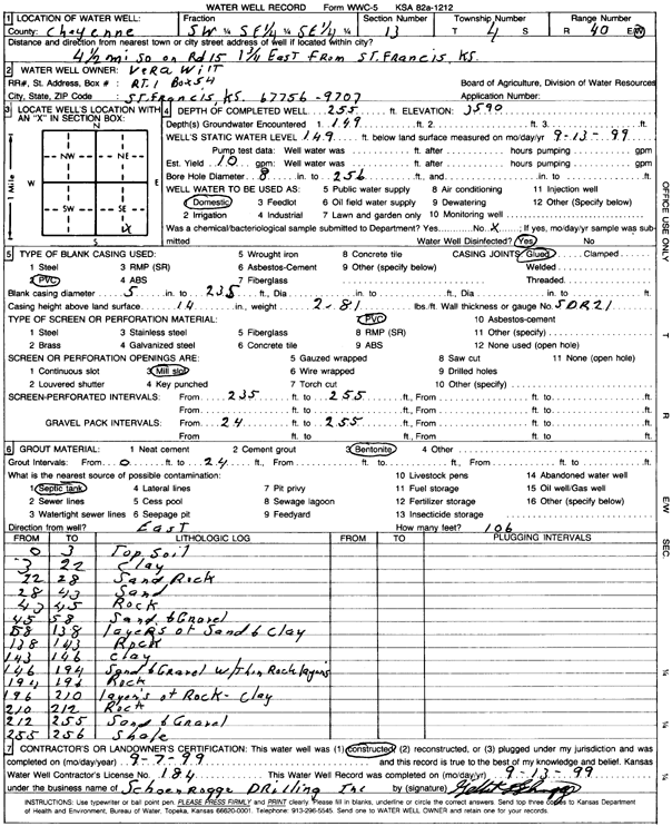
Specific Water Well Detail |
|
|
| Location Info | |||
| Owner: Willt, Vera | Status: Constructed | ||
| Location: T4S, R40W, Sec. 13, SW SE SE | County: Cheyenne | ||
| Directions: From St. Francis, 4.5 mi S on rd 15, 1.75 mi E | |||
| Latitude: 39.6995175 | Longitude: -101.7530297 | Datum NAD 27 | |
| Latitude: 39.6995111 | Longitude: -101.7534806 | Datum NAD 83 | |
| Longitude and latitude calculated by Survey from township-range-section-quarter calls. Only good to within the quarter call accuracy. | |||
| View well on interactive map | |||
| General Info | ||
| Well Depth: 255 ft. | Elevation: ft. | |
| Static Water Level: 149 ft. | Est. Yield: 10 gpm. | |
| Comp. Date: 07-Sep-1999 | Well Use: Domestic | |
| DWR Applic. #: | Other ID: | |
| Driller Info | ||
| Driller: Schoenrogge Drilling, Inc. | License #: 184 | |
| Scanned Form | View scan |
|
Chemical Sample Submitted?:
Water Well disinfected?: | ||
| Casing Info | ||
| Casing Type:
Casing Joints: |
Diam: in. to ft | |
| Casing height above land surface: in
Casing Weight: lbs/ft Wall thickness or gauge no.: | ||
| Screen and Perforation Info | ||
| Screen Type: | Screen Openings: | |
| Screen-perforated intervals | From: ft to ft | |
| Gravel pack intervals | From: ft to ft | |
| Grout Info | ||
| Grout used: | From: to ft | |
| Source of Possible Contamination | ||
| Source: | ||
| Direction from well: | Distance: ft | |
| Lithologic Log
(Log data entered by KGS.) | ||
| From: 0 ft. to 3 ft. | Top soil | |
| From: 3 ft. to 22 ft. | Clay | |
| From: 22 ft. to 28 ft. | Sand rock | |
| From: 28 ft. to 43 ft. | Sand | |
| From: 43 ft. to 45 ft. | Rock | |
| From: 45 ft. to 58 ft. | Sand and gravel | |
| From: 58 ft. to 138 ft. | Layers of sand and clay | |
| From: 138 ft. to 143 ft. | Rock | |
| From: 143 ft. to 146 ft. | Clay | |
| From: 146 ft. to 194 ft. | Sand and gravel with thin rock layers | |
| From: 194 ft. to 196 ft. | Rock | |
| From: 196 ft. to 210 ft. | Layers of rock, clay | |
| From: 210 ft. to 212 ft. | Rock | |
| From: 212 ft. to 255 ft. | Sand and gravel | |
| From: 255 ft. to 256 ft. | Shale | |